|
|
| Point ID: 139 | Downloads | Plots | Site Data | Code: 05AE023 |
|
| Download | |
|---|---|
| Site Descriptor Information | Site Time Series Data |
| Link to all available data | |
|
|
|
| View: | Statistics | All |
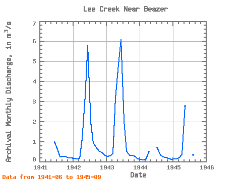
| Units: | mm |
| Year | Jan | Feb | Mar | Apr | May | Jun | Jul | Aug | Sep | Oct | Nov | Dec | Annual | 1941 | 0.99 | 0.62 | 0.24 | 0.27 | 0.26 | 0.18 | 0.18 | 1942 | 0.16 | 0.13 | 0.17 | 1.14 | 3.30 | 5.79 | 1.96 | 0.90 | 0.71 | 0.53 | 0.46 | 0.34 | 1.30 | 1943 | 0.27 | 0.28 | 0.40 | 3.17 | 4.85 | 6.09 | 2.04 | 0.52 | 0.32 | 0.31 | 0.26 | 0.13 | 1.55 | 1944 | 0.11 | 0.09 | 0.13 | 0.49 | 0.69 | 0.35 | 0.24 | 0.23 | 0.15 | 0.11 | 1945 | 0.14 | 0.14 | 0.21 | 0.36 | 2.76 | 5.93 | 1.35 | 0.33 | 0.32 |
|---|
 Return to R-Arctic Net Home Page