|
|
| Point ID: 9554 | Downloads | Plots | Site Data | Code: 05060510 |
|
| Download | |
|---|---|
| Site Descriptor Information | Site Time Series Data |
| Link to all available data | |
|
|
|
| View: | Statistics | All |
| Units: | m3/s |
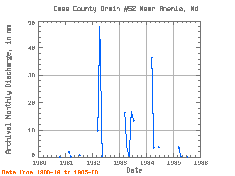
| Year | Jan | Feb | Mar | Apr | May | Jun | Jul | Aug | Sep | Oct | Nov | Dec | Annual | 1980 | 0.00 | 0.00 | 0.00 | 1981 | 0.00 | 1.95 | 0.10 | 0.00 | 0.00 | 0.00 | 0.61 | 0.00 | 0.00 | 1982 | 10.06 | 47.92 | 0.22 | 0.00 | 0.00 | 0.00 | 1983 | 16.68 | 3.88 | 0.05 | 16.49 | 13.85 | 0.04 | 1984 | 37.67 | 3.45 | 0.01 | 3.70 | 0.00 | 0.02 | 1985 | 3.72 | 0.26 | 20.95 | 0.02 | 0.00 | 0.00 |
|---|
 Return to R-Arctic Net Home Page