|
|
| Point ID: 9434 | Downloads | Plots | Site Data | Code: 15267000 |
|
| Download | |
|---|---|
| Site Descriptor Information | Site Time Series Data |
| Link to all available data | |
|
|
|
| View: | Statistics | All |
| Units: | m3/s |
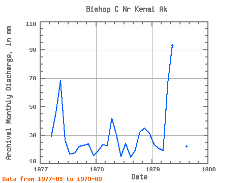
| Year | Jan | Feb | Mar | Apr | May | Jun | Jul | Aug | Sep | Oct | Nov | Dec | Annual | 1977 | 30.05 | 45.54 | 70.66 | 26.45 | 17.21 | 18.06 | 22.05 | 23.53 | 23.84 | 15.91 | 1978 | 19.31 | 21.73 | 23.41 | 41.71 | 31.17 | 14.86 | 24.99 | 15.04 | 19.27 | 32.97 | 35.00 | 32.38 | 311.94 | 1979 | 24.38 | 19.24 | 19.62 | 66.61 | 96.56 | 27.74 | 26.23 | 22.82 | 24.46 |
|---|
 Return to R-Arctic Net Home Page