|
|
| Point ID: 9341 | Downloads | Plots | Site Data | Code: 15303100 |
|
| Download | |
|---|---|
| Site Descriptor Information | Site Time Series Data |
| Link to all available data | |
|
|
|
| View: | Statistics | All |
| Units: | m3/s |
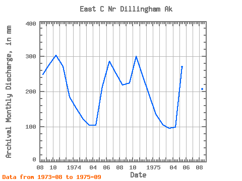
| Year | Jan | Feb | Mar | Apr | May | Jun | Jul | Aug | Sep | Oct | Nov | Dec | Annual | 1973 | 256.36 | 277.28 | 313.97 | 271.39 | 190.23 | 1974 | 157.48 | 113.87 | 107.47 | 104.24 | 221.01 | 286.37 | 259.37 | 225.58 | 224.70 | 310.83 | 244.19 | 195.65 | 2445.93 | 1975 | 139.98 | 98.83 | 98.19 | 97.81 | 278.63 | 386.11 | 314.91 | 214.67 | 272.35 |
|---|
 Return to R-Arctic Net Home Page