|
|
| Point ID: 8881 | Downloads | Plots | Site Data | Code: 70483 |
|
| Download | |
|---|---|
| Site Descriptor Information | Site Time Series Data |
| Link to all available data | |
|
|
|
| View: | Statistics | All |
| Units: | m3/s |
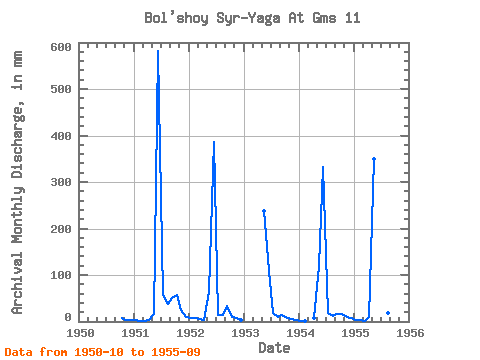
| Year | Jan | Feb | Mar | Apr | May | Jun | Jul | Aug | Sep | Oct | Nov | Dec | Annual | 1950 | 8.63 | 2.81 | 3.84 | 1951 | 2.40 | 1.47 | 0.56 | 3.29 | 16.43 | 581.99 | 59.02 | 39.75 | 49.79 | 59.57 | 24.63 | 10.08 | 855.39 | 1952 | 8.74 | 6.95 | 6.24 | 3.23 | 65.70 | 385.84 | 15.31 | 14.09 | 32.76 | 10.97 | 6.84 | 2.56 | 563.84 | 1953 | 245.53 | 108.85 | 19.10 | 10.02 | 13.74 | 8.57 | 4.42 | 3.06 | 1954 | 1.56 | 0.96 | 7.54 | 122.49 | 333.03 | 19.93 | 11.91 | 16.22 | 16.09 | 10.62 | 8.35 | 1955 | 4.40 | 2.64 | 0.61 | 9.00 | 361.89 | 54.43 | 22.05 | 19.77 | 33.68 |
|---|
 Return to R-Arctic Net Home Page