|
|
| Point ID: 7997 | Downloads | Plots | Site Data | Code: 3652 |
|
| Download | |
|---|---|
| Site Descriptor Information | Site Time Series Data |
| Link to all available data | |
|
|
|
| View: | Statistics | All |
| Units: | m3/s |
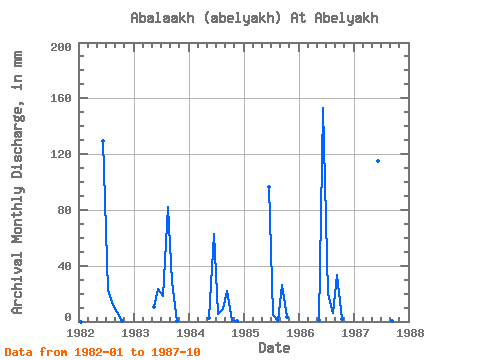
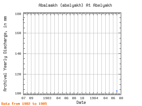
| Year | Jan | Feb | Mar | Apr | May | Jun | Jul | Aug | Sep | Oct | Nov | Dec | Annual | 1982 | 0.00 | 0.00 | 0.00 | 0.00 | 0.00 | 129.32 | 23.16 | 12.51 | 6.67 | 0.14 | 0.00 | 0.00 | 173.14 | 1983 | 0.00 | 0.00 | 0.00 | 0.00 | 10.68 | 23.12 | 18.82 | 84.54 | 28.02 | 0.49 | 0.00 | 0.00 | 164.37 | 1984 | 0.00 | 0.00 | 0.00 | 0.00 | 2.37 | 62.49 | 5.57 | 9.37 | 22.14 | 0.69 | 0.02 | 0.00 | 103.57 | 1985 | 0.00 | 0.00 | 0.00 | 0.00 | 0.00 | 96.39 | 4.98 | 0.10 | 25.92 | 3.20 | 0.00 | 0.00 | 132.24 | 1986 | 1.26 | 152.72 | 20.70 | 6.12 | 33.63 | 1.71 | 0.00 | 1987 | 115.03 | 23.45 | 0.48 | 0.18 | 0.00 |
|---|
 Return to R-Arctic Net Home Page