|
|
| Point ID: 7302 | Downloads | Plots | Site Data | Other Close Sites | Code: 49081 |
|
| Download | |
|---|---|
| Site Descriptor Information | Site Time Series Data |
| Link to all available data | |
|
|
|
| View: | Statistics | All |
| Units: | m3/s |
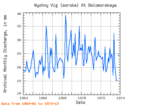
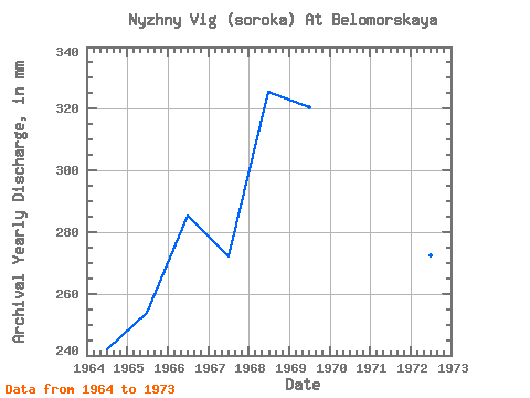
| Year | Jan | Feb | Mar | Apr | May | Jun | Jul | Aug | Sep | Oct | Nov | Dec | Annual | 1964 | 19.54 | 17.53 | 19.04 | 18.72 | 23.11 | 19.78 | 19.74 | 18.75 | 19.20 | 20.43 | 21.98 | 24.30 | 242.06 | 1965 | 27.18 | 21.87 | 21.03 | 16.32 | 18.75 | 18.05 | 18.05 | 21.13 | 22.66 | 21.62 | 22.18 | 25.09 | 254.04 | 1966 | 17.85 | 19.16 | 19.24 | 19.49 | 36.30 | 32.93 | 27.18 | 17.56 | 15.94 | 28.07 | 24.19 | 27.87 | 285.50 | 1967 | 20.83 | 18.25 | 19.04 | 18.34 | 33.03 | 27.36 | 20.14 | 22.61 | 22.56 | 24.10 | 23.23 | 23.01 | 272.35 | 1968 | 23.11 | 20.24 | 16.46 | 19.68 | 40.27 | 35.33 | 25.39 | 22.81 | 26.98 | 30.55 | 30.43 | 34.72 | 325.73 | 1969 | 24.10 | 23.59 | 29.86 | 24.10 | 33.42 | 20.74 | 22.52 | 25.89 | 26.59 | 36.20 | 26.11 | 27.97 | 320.76 | 1970 | 26.98 | 26.75 | 21.62 | 20.64 | 33.03 | 28.90 | 22.22 | 23.70 | 26.59 | 28.66 | 25.34 | 28.57 | 313.26 | 1971 | 25.79 | 22.50 | 22.61 | 19.10 | 30.25 | 30.91 | 23.11 | 24.30 | 24.00 | 26.88 | 23.90 | 24.89 | 298.26 | 1972 | 24.20 | 21.69 | 24.60 | 18.62 | 22.52 | 27.46 | 18.84 | 19.44 | 21.12 | 24.40 | 21.70 | 27.97 | 272.64 | 1973 | 23.90 | 23.32 | 24.60 | 16.99 | 33.42 | 22.18 | 18.94 | 15.67 | 15.17 | 25.49 | 24.38 | 28.76 | 272.74 |
|---|
| Other Close Sites | ||||||
|---|---|---|---|---|---|---|
| PointID | Latitude | Longitude | Drainage Area | Source | Name | |
| 7300 | "Belomorkanal At Matkozh" | 64.43 | -2323887 | SHI | 21.00 | |
| 7301 | "Nyzhny Vig (Soroka) At Vigostrov" | 64.48 | -2314678 | SHI | 11.00 | |
 Return to R-Arctic Net Home Page