|
|
| Point ID: 5381 | Downloads | Plots | Site Data | Code: 05JG010 |
|
| Download | |
|---|---|
| Site Descriptor Information | Site Time Series Data |
| Link to all available data | |
|
|
|
| View: | Statistics | All |
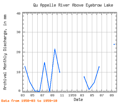
| Units: | m3/s |
| Year | Jan | Feb | Mar | Apr | May | Jun | Jul | Aug | Sep | Oct | Nov | Dec | Annual | 1958 | 5.71 | 2.18 | 0.21 | 0.16 | 6.60 | 0.06 | 9.24 | 4.42 | 1959 | 3.32 | 0.55 | 2.09 | 5.38 | 12.06 | 16.98 | 10.20 | 1.66 |
|---|
 Return to R-Arctic Net Home Page