|
|
| Point ID: 408 | Downloads | Plots | Site Data | Code: 05CG005 |
|
| Download | |
|---|---|
| Site Descriptor Information | Site Time Series Data |
| Link to all available data | |
|
|
|
| View: | Statistics | All |
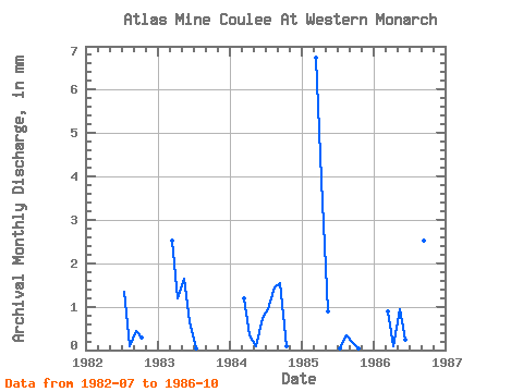
| Units: | m3/s |
| Year | Jan | Feb | Mar | Apr | May | Jun | Jul | Aug | Sep | Oct | Nov | Dec | Annual | 1982 | 1.38 | 0.10 | 0.45 | 0.31 | 1983 | 2.61 | 1.19 | 1.69 | 0.64 | 0.05 | 0.00 | 0.00 | 0.00 | 1984 | 1.23 | 0.35 | 0.10 | 0.74 | 0.97 | 1.48 | 1.54 | 0.10 | 1985 | 6.96 | 3.92 | 0.92 | 0.00 | 0.05 | 0.36 | 0.20 | 0.05 | 1986 | 0.92 | 0.10 | 0.97 | 0.25 | 0.41 | 0.05 | 2.53 | 0.51 |
|---|
 Return to R-Arctic Net Home Page