|
|
| Point ID: 269 | Downloads | Plots | Site Data | Code: 05BF020 |
|
| Download | |
|---|---|
| Site Descriptor Information | Site Time Series Data |
| Link to all available data | |
|
|
|
| View: | Statistics | All |
| Units: | m3/s |
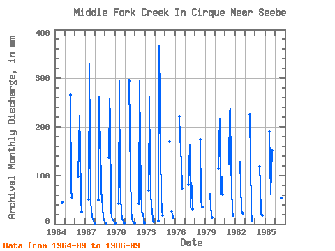
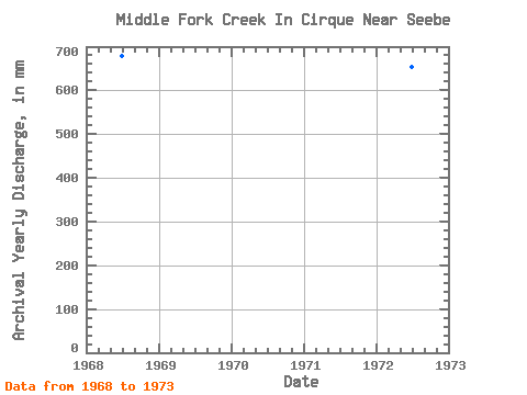
| Year | Jan | Feb | Mar | Apr | May | Jun | Jul | Aug | Sep | Oct | Nov | Dec | Annual | 1964 | 44.69 | 1965 | 274.73 | 73.88 | 55.86 | 1966 | 101.58 | 223.45 | 163.91 | 50.79 | 24.58 | 1967 | 53.10 | 330.70 | 187.00 | 46.17 | 15.64 | 11.54 | 4.47 | 2.31 | 1968 | 2.31 | 0.00 | 0.00 | 0.00 | 50.79 | 263.67 | 170.84 | 76.18 | 49.16 | 39.25 | 11.17 | 6.93 | 668.84 | 1969 | 2.31 | 2.10 | 140.83 | 256.97 | 223.94 | 30.01 | 13.41 | 9.23 | 4.47 | 2.31 | 1970 | 2.31 | 0.00 | 0.00 | 0.00 | 43.86 | 294.95 | 96.96 | 23.09 | 11.17 | 9.23 | 4.47 | 2.31 | 489.72 | 1971 | 0.00 | 0.00 | 0.00 | 294.95 | 103.89 | 30.01 | 11.17 | 9.23 | 2.23 | 2.31 | 1972 | 0.00 | 0.00 | 0.00 | 0.00 | 43.86 | 294.95 | 170.84 | 76.18 | 24.58 | 23.09 | 8.94 | 2.31 | 643.90 | 1973 | 0.00 | 0.00 | 0.00 | 0.00 | 71.57 | 261.43 | 131.59 | 25.39 | 31.28 | 6.93 | 4.47 | 0.00 | 532.80 | 1974 | 0.00 | 0.00 | 0.00 | 0.00 | 6.93 | 366.45 | 152.37 | 57.72 | 29.05 | 18.47 | 1975 | 169.82 | 26.81 | 13.85 | 1976 | 221.21 | 187.00 | 129.28 | 73.74 | 1977 | 83.11 | 163.12 | 34.63 | 87.73 | 75.97 | 32.32 | 1978 | 180.07 | 55.41 | 35.75 | 36.94 | 1979 | 62.33 | 18.47 | 13.41 | 1980 | 117.74 | 216.75 | 62.33 | 66.95 | 98.32 | 62.33 | 1981 | 129.28 | 230.15 | 244.71 | 126.97 | 26.81 | 18.47 | 1982 | 131.59 | 32.32 | 22.34 | 23.09 | 1983 | 225.68 | 133.90 | 27.70 | 6.70 | 1984 | 118.43 | 83.11 | 20.78 | 17.88 | 1985 | 189.93 | 62.33 | 110.81 | 151.94 | 1986 | 281.55 | 94.65 | 55.41 | 35.75 |
|---|
 Return to R-Arctic Net Home Page