|
|
|||||||||||||||||
| Point ID: 6555 | Downloads | Plots | Site Data | Other Close Sites | Code: 9127 |
|
|
|||||||||||||||||
| Download | |
|---|---|
| Site Descriptor Information | Site Time Series Data |
| Link to all available data | |
|
|
| View: | Statistics | Time Series |
| Units: | mm |
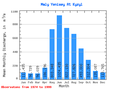
| Statistic | Jan | Feb | Mar | Apr | May | Jun | Jul | Aug | Sep | Oct | Nov | Dec | Annual |
|---|---|---|---|---|---|---|---|---|---|---|---|---|---|
| Mean | 111.44 | 96.74 | 96.04 | 186.20 | 803.35 | 1024.43 | 822.13 | 727.83 | 493.00 | 312.30 | 135.09 | 113.77 | 410.19 |
| Standard Deviation | 21.88 | 16.06 | 17.50 | 62.10 | 224.02 | 325.45 | 262.41 | 221.47 | 120.32 | 65.20 | 31.23 | 22.77 | 64.79 |
| Min | 80.30 | 77.40 | 76.30 | 95.50 | 453.00 | 476.00 | 454.00 | 380.00 | 314.00 | 183.00 | 89.80 | 81.80 | 306.43 |
| Max | 149.00 | 129.00 | 134.00 | 363.00 | 1250.00 | 1680.00 | 1340.00 | 1320.00 | 808.00 | 461.00 | 244.00 | 164.00 | 490.80 |
| Coefficient of Variation | 0.20 | 0.17 | 0.18 | 0.33 | 0.28 | 0.32 | 0.32 | 0.30 | 0.24 | 0.21 | 0.23 | 0.20 | 0.16 |
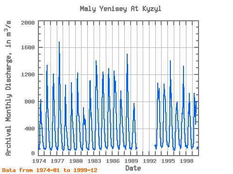
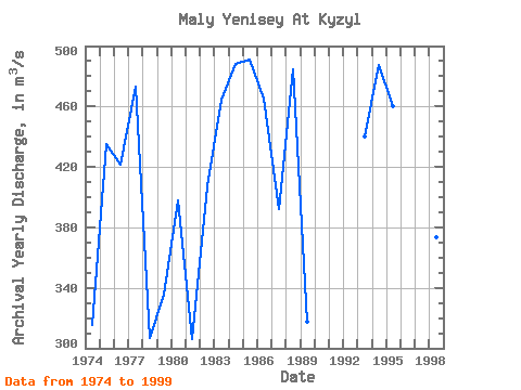
| Year | Jan | Feb | Mar | Apr | May | Jun | Jul | Aug | Sep | Oct | Nov | Dec | Annual | 1974 | 103.00 | 91.10 | 86.70 | 234.00 | 709.00 | 831.00 | 468.00 | 480.00 | 350.00 | 228.00 | 105.00 | 99.30 | 315.43 | 1975 | 102.00 | 91.90 | 93.50 | 115.00 | 1150.00 | 1340.00 | 723.00 | 656.00 | 456.00 | 271.00 | 124.00 | 97.10 | 434.96 | 1976 | 94.60 | 78.40 | 80.70 | 144.00 | 827.00 | 1210.00 | 927.00 | 722.00 | 457.00 | 255.00 | 132.00 | 128.00 | 421.31 | 1977 | 99.00 | 79.80 | 83.90 | 173.00 | 636.00 | 1680.00 | 1340.00 | 762.00 | 372.00 | 259.00 | 101.00 | 93.00 | 473.23 | 1978 | 80.30 | 78.30 | 95.10 | 182.00 | 684.00 | 1040.00 | 467.00 | 380.00 | 314.00 | 183.00 | 94.20 | 85.30 | 306.93 | 1979 | 87.70 | 83.00 | 76.30 | 106.00 | 1080.00 | 769.00 | 589.00 | 404.00 | 378.00 | 254.00 | 121.00 | 81.80 | 335.82 | 1980 | 85.00 | 85.00 | 81.80 | 108.00 | 1060.00 | 1220.00 | 641.00 | 567.00 | 409.00 | 273.00 | 127.00 | 117.00 | 397.82 | 1981 | 98.80 | 82.30 | 77.00 | 230.00 | 708.00 | 476.00 | 454.00 | 538.00 | 498.00 | 281.00 | 129.00 | 105.00 | 306.43 | 1982 | 94.30 | 80.00 | 84.70 | 257.00 | 1100.00 | 1110.00 | 585.00 | 637.00 | 453.00 | 269.00 | 128.00 | 90.30 | 407.36 | 1983 | 99.30 | 92.50 | 83.80 | 95.50 | 628.00 | 1400.00 | 1130.00 | 807.00 | 572.00 | 386.00 | 176.00 | 107.00 | 464.76 | 1984 | 109.00 | 93.20 | 84.90 | 126.00 | 694.00 | 1020.00 | 1240.00 | 1160.00 | 677.00 | 392.00 | 143.00 | 119.00 | 488.18 | 1985 | 117.00 | 109.00 | 98.60 | 168.00 | 1120.00 | 1290.00 | 1000.00 | 745.00 | 606.00 | 354.00 | 150.00 | 132.00 | 490.80 | 1986 | 118.00 | 103.00 | 101.00 | 148.00 | 1250.00 | 938.00 | 1100.00 | 765.00 | 486.00 | 292.00 | 151.00 | 132.00 | 465.33 | 1987 | 109.00 | 92.90 | 99.70 | 221.00 | 708.00 | 959.00 | 704.00 | 705.00 | 457.00 | 388.00 | 134.00 | 132.00 | 392.47 | 1988 | 142.00 | 116.00 | 90.60 | 207.00 | 935.00 | 1500.00 | 1210.00 | 684.00 | 417.00 | 291.00 | 121.00 | 98.30 | 484.32 | 1989 | 108.00 | 93.20 | 90.60 | 209.00 | 453.00 | 569.00 | 771.00 | 644.00 | 397.00 | 272.00 | 89.80 | 114.00 | 317.55 | 1993 | 149.00 | 107.00 | 98.80 | 176.00 | 598.00 | 1070.00 | 845.00 | 990.00 | 605.00 | 363.00 | 146.00 | 134.00 | 440.15 | 1994 | 119.00 | 123.00 | 134.00 | 236.00 | 752.00 | 1060.00 | 897.00 | 855.00 | 808.00 | 461.00 | 244.00 | 164.00 | 487.75 | 1995 | 146.00 | 129.00 | 130.00 | 237.00 | 628.00 | 1400.00 | 846.00 | 919.00 | 503.00 | 348.00 | 144.00 | 91.80 | 460.15 | 1996 | 83.00 | 77.40 | 78.20 | 136.00 | 565.00 | 757.00 | 791.00 | 555.00 | 468.00 | 315.00 | 157.00 | 155.00 | 344.80 | 1997 | 147.00 | 103.00 | 121.00 | 363.00 | 626.00 | 616.00 | 799.00 | 1320.00 | 702.00 | 383.00 | 131.00 | 144.00 | 454.58 | 1998 | 144.00 | 112.00 | 109.00 | 189.00 | 648.00 | 619.00 | 923.00 | 655.00 | 498.00 | 349.00 | 138.00 | 98.90 | 373.57 | 1999 | 128.00 | 124.00 | 129.00 | 222.00 | 918.00 | 688.00 | 459.00 | 790.00 | 456.00 | 316.00 | 121.00 | 97.80 | 370.73 |
|---|
| Other Close Sites | ||||||
|---|---|---|---|---|---|---|
| PointID | Latitude | Longitude | Drainage Area | Source | Name | |
| 6537 | "Yenisey at Kyizyil" | 51.72 | 320529 | SHI | 3486.00 | |
| 6548 | "Bol'shoy Yenisey At Kara-Khak" | 51.88 | 324040 | SHI | 20.00 | |
 Return to R-Arctic Net Home Page