|
|
|||||||||||||||||
| Point ID: 9604 | Downloads | Plots | Site Data | Code: 05062200 |
|
|
|||||||||||||||||
| Download | |
|---|---|
| Site Descriptor Information | Site Time Series Data |
| Link to all available data | |
|
|
| View: | Statistics | Time Series |
| Units: | m3/s |
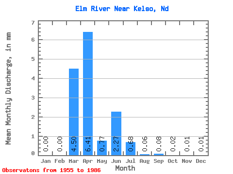
| Statistic | Jan | Feb | Mar | Apr | May | Jun | Jul | Aug | Sep | Oct | Nov | Dec | Annual |
|---|---|---|---|---|---|---|---|---|---|---|---|---|---|
| Mean | 0.00 | 0.00 | 4.49 | 6.41 | 0.77 | 2.27 | 0.68 | 0.06 | 0.08 | 0.02 | 0.01 | 0.01 | 4.72 |
| Standard Deviation | 0.00 | 0.00 | 7.68 | 9.46 | 1.09 | 5.27 | 1.61 | 0.16 | 0.25 | 0.06 | 0.03 | 0.03 | 8.45 |
| Min | 0.00 | 0.00 | 0.00 | 0.00 | 0.00 | 0.00 | 0.00 | 0.00 | 0.00 | 0.00 | 0.00 | 0.00 | 0.00 |
| Max | 0.00 | 0.00 | 21.58 | 34.19 | 3.60 | 15.86 | 5.53 | 0.59 | 0.74 | 0.16 | 0.08 | 0.07 | 22.87 |
| Coefficient of Variation | 3.00 | 3.00 | 1.71 | 1.48 | 1.41 | 2.32 | 2.37 | 2.60 | 3.00 | 2.40 | 3.00 | 3.00 | 1.79 |
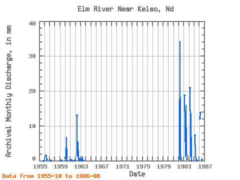
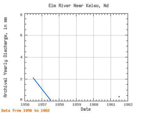
| Year | Jan | Feb | Mar | Apr | May | Jun | Jul | Aug | Sep | Oct | Nov | Dec | Annual | 1955 | 0.00 | 0.00 | 0.00 | 1956 | 0.00 | 0.00 | 0.00 | 1.45 | 0.30 | 0.29 | 0.00 | 0.00 | 0.00 | 0.00 | 0.00 | 0.00 | 2.07 | 1957 | 0.00 | 0.00 | 0.04 | 0.02 | 0.00 | 0.00 | 0.00 | 0.00 | 0.00 | 0.00 | 0.00 | 0.00 | 0.06 | 1958 | 0.00 | 0.00 | 0.00 | 0.00 | 0.00 | 0.00 | 0.00 | 0.00 | 0.00 | 0.00 | 0.00 | 0.00 | 0.00 | 1959 | 0.00 | 0.00 | 0.10 | 0.03 | 0.00 | 0.00 | 0.00 | 0.00 | 0.00 | 0.00 | 0.00 | 0.00 | 0.13 | 1960 | 0.00 | 0.00 | 0.76 | 6.67 | 0.02 | 0.00 | 0.00 | 0.00 | 0.00 | 0.00 | 0.00 | 0.00 | 7.54 | 1961 | 0.00 | 0.00 | 0.28 | 0.03 | 0.01 | 0.00 | 0.00 | 0.00 | 0.00 | 0.04 | 0.00 | 0.00 | 0.35 | 1962 | 0.00 | 0.00 | 0.00 | 13.03 | 1.67 | 1.27 | 5.53 | 0.21 | 0.74 | 0.16 | 0.08 | 0.07 | 22.87 | 1963 | 0.00 | 0.00 | 0.25 | 1.26 | 0.14 | 0.07 | 0.00 | 0.00 | 0.00 | 1980 | 0.00 | 0.00 | 0.00 | 1981 | 0.00 | 0.00 | 0.00 | 0.00 | 0.00 | 0.00 | 0.00 | 0.00 | 0.00 | 1982 | 0.69 | 34.19 | 2.13 | 0.33 | 0.42 | 0.00 | 1983 | 19.27 | 9.72 | 1.33 | 15.86 | 3.02 | 0.59 | 1984 | 21.58 | 7.78 | 1.22 | 13.40 | 0.08 | 0.00 | 1985 | 7.40 | 1.67 | 0.40 | 0.15 | 0.00 | 0.05 | 1986 | 12.54 | 13.89 | 3.60 | 0.40 | 0.45 | 0.02 |
|---|
 Return to R-Arctic Net Home Page