|
|
|||||||||||||||||
| Point ID: 9571 | Downloads | Plots | Site Data | Code: 05116150 |
|
|
|||||||||||||||||
| Download | |
|---|---|
| Site Descriptor Information | Site Time Series Data |
| Link to all available data | |
|
|
| View: | Statistics | Time Series |
| Units: | m3/s |
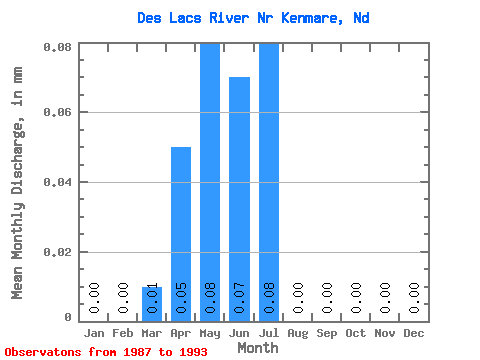
| Statistic | Jan | Feb | Mar | Apr | May | Jun | Jul | Aug | Sep | Oct | Nov | Dec | Annual |
|---|---|---|---|---|---|---|---|---|---|---|---|---|---|
| Mean | 0.00 | 0.00 | 0.01 | 0.05 | 0.08 | 0.07 | 0.08 | 0.01 | 0.00 | 0.00 | 0.00 | 0.00 | 0.32 |
| Standard Deviation | 0.00 | 0.00 | 0.03 | 0.12 | 0.20 | 0.16 | 0.13 | 0.01 | 0.00 | 0.00 | 0.00 | 0.00 | 0.71 |
| Min | 0.00 | 0.00 | 0.00 | 0.00 | 0.00 | 0.00 | 0.00 | 0.00 | 0.00 | 0.00 | 0.00 | 0.00 | 0.00 |
| Max | 0.00 | 0.00 | 0.07 | 0.28 | 0.50 | 0.40 | 0.32 | 0.02 | 0.01 | 0.01 | 0.00 | 0.00 | 1.60 |
| Coefficient of Variation | 2.45 | 2.41 | 2.41 | 2.42 | 2.44 | 1.75 | 1.75 | 2.45 | 1.92 | 1.70 | 2.06 | 2.22 |
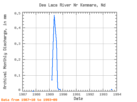
| Year | Jan | Feb | Mar | Apr | May | Jun | Jul | Aug | Sep | Oct | Nov | Dec | Annual | 1987 | 0.00 | 0.00 | 0.00 | 1988 | 0.00 | 0.00 | 0.00 | 0.00 | 0.01 | 0.00 | 0.00 | 0.00 | 0.00 | 0.00 | 0.00 | 0.00 | 0.01 | 1989 | 0.00 | 0.00 | 0.07 | 0.28 | 0.50 | 0.40 | 0.32 | 0.02 | 0.01 | 0.01 | 0.00 | 0.00 | 1.60 | 1990 | 0.00 | 0.00 | 0.00 | 0.00 | 0.00 | 0.00 | 0.00 | 0.00 | 0.00 | 0.00 | 0.00 | 0.00 | 0.01 | 1991 | 0.00 | 0.00 | 0.00 | 0.00 | 0.00 | 0.00 | 0.00 | 0.00 | 0.00 | 0.00 | 0.00 | 0.00 | 0.00 | 1992 | 0.00 | 0.00 | 0.00 | 0.00 | 0.00 | 0.00 | 0.00 | 0.00 | 0.00 | 0.00 | 0.00 | 0.00 | 0.00 | 1993 | 0.00 | 0.00 | 0.00 | 0.00 | 0.00 | 0.00 | 0.13 | 0.01 | 0.00 |
|---|
 Return to R-Arctic Net Home Page