|
|
|||||||||||||||||
| Point ID: 9546 | Downloads | Plots | Site Data | Code: 05078520 |
|
|
|||||||||||||||||
| Download | |
|---|---|
| Site Descriptor Information | Site Time Series Data |
| Link to all available data | |
|
|
| View: | Statistics | Time Series |
| Units: | m3/s |
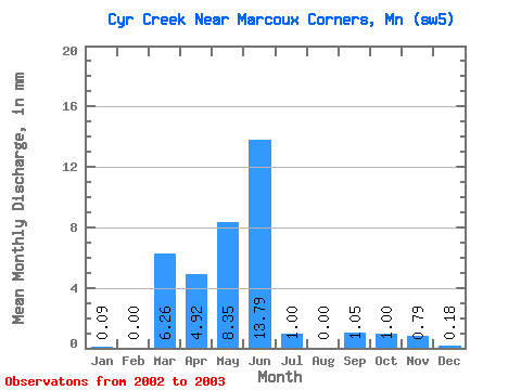
| Statistic | Jan | Feb | Mar | Apr | May | Jun | Jul | Aug | Sep | Oct | Nov | Dec | Annual |
|---|---|---|---|---|---|---|---|---|---|---|---|---|---|
| Mean | 0.07 | 0.00 | 6.31 | 4.90 | 8.32 | 13.76 | 1.00 | 0.01 | 1.06 | 1.02 | 0.79 | 0.16 | |
| Standard Deviation | 1.51 | ||||||||||||
| Min | 0.07 | 0.00 | 6.31 | 4.90 | 8.32 | 13.76 | 1.00 | 0.01 | 0.00 | 1.02 | 0.79 | 0.16 | |
| Max | 0.07 | 0.00 | 6.31 | 4.90 | 8.32 | 13.76 | 1.00 | 0.01 | 2.13 | 1.02 | 0.79 | 0.16 | |
| Coefficient of Variation | 1.41 |
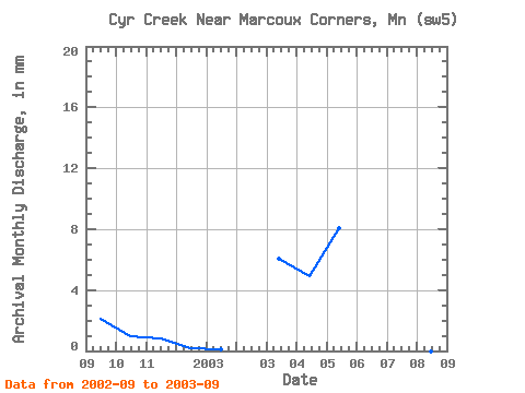
| Year | Jan | Feb | Mar | Apr | May | Jun | Jul | Aug | Sep | Oct | Nov | Dec | Annual | 2002 | 2.13 | 1.02 | 0.79 | 0.16 | 2003 | 0.07 | 0.00 | 6.31 | 4.90 | 8.32 | 13.76 | 1.00 | 0.01 | 0.00 |
|---|
 Return to R-Arctic Net Home Page