|
|
|||||||||||||||||
| Point ID: 9522 | Downloads | Plots | Site Data | Code: 15292400 |
|
|
|||||||||||||||||
| Download | |
|---|---|
| Site Descriptor Information | Site Time Series Data |
| Link to all available data | |
|
|
| View: | Statistics | Time Series |
| Units: | m3/s |
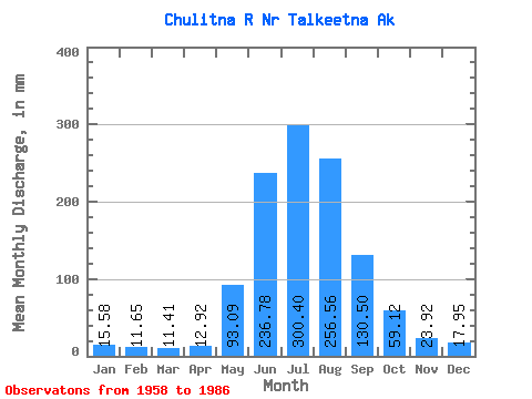
| Statistic | Jan | Feb | Mar | Apr | May | Jun | Jul | Aug | Sep | Oct | Nov | Dec | Annual |
|---|---|---|---|---|---|---|---|---|---|---|---|---|---|
| Mean | 15.58 | 11.76 | 11.41 | 12.92 | 93.07 | 236.78 | 300.35 | 256.52 | 130.50 | 59.11 | 23.92 | 17.95 | 1173.04 |
| Standard Deviation | 3.34 | 1.96 | 1.82 | 2.52 | 33.18 | 57.68 | 43.22 | 54.26 | 39.95 | 16.15 | 5.46 | 4.18 | 125.82 |
| Min | 11.10 | 8.51 | 8.41 | 7.72 | 26.83 | 162.24 | 237.22 | 128.79 | 73.92 | 33.02 | 16.32 | 11.39 | 841.36 |
| Max | 23.30 | 15.64 | 14.81 | 17.64 | 158.28 | 444.74 | 405.25 | 383.64 | 245.49 | 98.18 | 35.43 | 27.20 | 1465.15 |
| Coefficient of Variation | 0.21 | 0.17 | 0.16 | 0.20 | 0.36 | 0.24 | 0.14 | 0.21 | 0.31 | 0.27 | 0.23 | 0.23 | 0.11 |
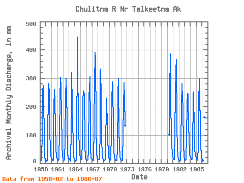
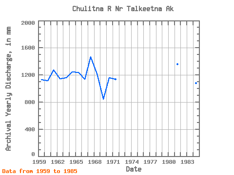
| Year | Jan | Feb | Mar | Apr | May | Jun | Jul | Aug | Sep | Oct | Nov | Dec | Annual | 1958 | 10.84 | 10.80 | 13.45 | 119.17 | 255.49 | 284.96 | 236.49 | 88.21 | 47.82 | 20.76 | 14.38 | 1959 | 12.49 | 10.89 | 8.41 | 9.81 | 84.45 | 260.86 | 292.24 | 251.78 | 109.80 | 53.81 | 25.18 | 19.37 | 1132.92 | 1960 | 16.50 | 11.45 | 10.63 | 11.03 | 158.28 | 191.79 | 269.45 | 220.13 | 136.99 | 58.50 | 21.50 | 19.88 | 1118.84 | 1961 | 16.54 | 11.42 | 12.29 | 17.64 | 115.06 | 225.94 | 312.34 | 280.00 | 176.79 | 65.81 | 26.46 | 17.09 | 1270.15 | 1962 | 14.81 | 10.38 | 10.60 | 12.90 | 88.22 | 227.41 | 310.10 | 250.42 | 148.79 | 39.94 | 16.54 | 17.68 | 1141.41 | 1963 | 18.23 | 13.49 | 9.64 | 7.72 | 126.05 | 195.69 | 329.80 | 209.48 | 124.97 | 91.85 | 25.36 | 11.39 | 1155.63 | 1964 | 11.47 | 8.51 | 8.77 | 12.50 | 26.83 | 444.74 | 278.35 | 230.72 | 101.83 | 64.28 | 31.98 | 23.92 | 1241.68 | 1965 | 18.23 | 14.53 | 14.81 | 15.44 | 84.89 | 221.31 | 264.64 | 256.88 | 245.49 | 69.16 | 17.86 | 15.38 | 1234.12 | 1966 | 13.67 | 11.42 | 12.53 | 14.34 | 45.24 | 239.69 | 270.56 | 315.80 | 134.52 | 53.34 | 18.52 | 17.09 | 1140.52 | 1967 | 16.61 | 13.05 | 11.91 | 10.71 | 141.27 | 281.44 | 405.25 | 383.64 | 137.97 | 39.68 | 18.30 | 15.91 | 1465.15 | 1968 | 14.07 | 12.46 | 13.08 | 14.85 | 124.62 | 319.81 | 343.36 | 235.97 | 81.32 | 33.02 | 16.32 | 12.97 | 1215.24 | 1969 | 11.10 | 9.34 | 9.39 | 14.70 | 68.36 | 204.60 | 237.22 | 128.79 | 73.92 | 52.16 | 20.80 | 14.99 | 841.36 | 1970 | 13.67 | 11.97 | 12.53 | 15.84 | 109.85 | 216.86 | 297.38 | 280.92 | 124.97 | 43.59 | 24.37 | 15.99 | 1160.61 | 1971 | 12.68 | 9.86 | 10.64 | 10.82 | 50.90 | 244.57 | 310.80 | 271.25 | 122.18 | 61.96 | 23.78 | 16.32 | 1139.25 | 1972 | 13.38 | 10.81 | 10.69 | 9.85 | 111.24 | 197.34 | 293.63 | 238.91 | 133.60 | 1980 | 104.15 | 247.96 | 398.15 | 236.78 | 90.86 | 65.06 | 35.43 | 22.97 | 1981 | 18.48 | 14.68 | 13.34 | 15.88 | 113.60 | 247.18 | 340.20 | 377.87 | 131.89 | 55.00 | 24.85 | 13.89 | 1357.46 | 1982 | 11.74 | 9.06 | 8.98 | 11.82 | 71.64 | 202.41 | 291.76 | 232.00 | 201.09 | 62.65 | 27.71 | 21.11 | 1146.65 | 1983 | 17.92 | 10.79 | 11.96 | 13.77 | 101.17 | 208.29 | 254.28 | 252.81 | 120.91 | 98.18 | 32.23 | 27.20 | 1142.15 | 1984 | 23.30 | 15.64 | 14.33 | 15.18 | 83.33 | 205.08 | 253.76 | 259.49 | 109.39 | 53.84 | 29.48 | 24.62 | 1081.16 | 1985 | 21.68 | 14.49 | 13.27 | 12.46 | 65.08 | 208.41 | 309.25 | 236.78 | 145.05 | 72.47 | 20.95 | 16.87 | 1130.39 | 1986 | 14.99 | 11.75 | 10.93 | 10.54 | 54.17 | 162.24 | 260.23 |
|---|
 Return to R-Arctic Net Home Page