|
|
|||||||||||||||||
| Point ID: 9508 | Downloads | Plots | Site Data | Code: 15277800 |
|
|
|||||||||||||||||
| Download | |
|---|---|
| Site Descriptor Information | Site Time Series Data |
| Link to all available data | |
|
|
| View: | Statistics | Time Series |
| Units: | m3/s |
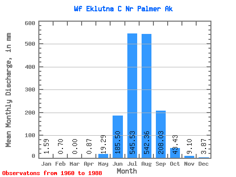
| Statistic | Jan | Feb | Mar | Apr | May | Jun | Jul | Aug | Sep | Oct | Nov | Dec | Annual |
|---|---|---|---|---|---|---|---|---|---|---|---|---|---|
| Mean | 1.57 | 0.69 | 0.00 | 0.86 | 19.30 | 185.51 | 545.44 | 542.26 | 208.01 | 43.41 | 9.11 | 3.85 | 1484.26 |
| Standard Deviation | 0.88 | 0.49 | 0.00 | 0.48 | 10.71 | 95.39 | 93.39 | 125.49 | 38.50 | 29.86 | 4.56 | 1.68 | 149.68 |
| Min | 0.37 | 0.00 | 0.00 | 0.55 | 11.29 | 72.03 | 414.28 | 394.81 | 131.59 | 20.96 | 3.35 | 1.14 | 1301.92 |
| Max | 2.50 | 1.27 | 0.00 | 1.71 | 36.95 | 314.04 | 690.70 | 799.11 | 255.11 | 101.94 | 16.84 | 5.77 | 1654.85 |
| Coefficient of Variation | 0.56 | 0.71 | 0.56 | 0.56 | 0.51 | 0.17 | 0.23 | 0.18 | 0.69 | 0.50 | 0.44 | 0.10 |
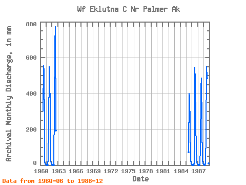
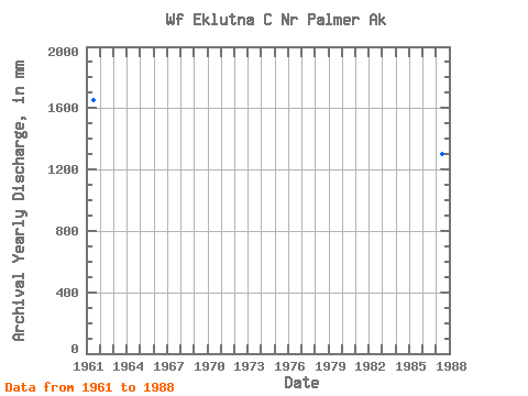
| Year | Jan | Feb | Mar | Apr | May | Jun | Jul | Aug | Sep | Oct | Nov | Dec | Annual | 1960 | 302.81 | 574.22 | 540.62 | 207.77 | 20.96 | 7.80 | 4.60 | 1961 | 2.32 | 1.04 | 0.00 | 0.75 | 36.95 | 206.92 | 567.35 | 567.83 | 255.11 | 26.73 | 3.35 | 1.14 | 1654.85 | 1962 | 0.37 | 0.00 | 0.00 | 0.55 | 21.83 | 314.04 | 690.70 | 799.11 | 194.83 | 1985 | 72.03 | 414.28 | 394.81 | 219.15 | 33.38 | 6.51 | 2.80 | 1986 | 1.14 | 0.52 | 0.00 | 0.55 | 12.16 | 136.79 | 564.94 | 486.46 | 228.07 | 101.94 | 16.84 | 5.06 | 1539.11 | 1987 | 1.52 | 0.63 | 0.00 | 1.71 | 11.29 | 93.70 | 437.03 | 503.48 | 219.56 | 31.49 | 10.67 | 3.72 | 1301.92 | 1988 | 2.50 | 1.27 | 0.00 | 0.74 | 14.26 | 172.30 | 569.54 | 503.52 | 131.59 | 45.95 | 9.48 | 5.77 | 1441.17 |
|---|
 Return to R-Arctic Net Home Page