|
|
|||||||||||||||||
| Point ID: 9501 | Downloads | Plots | Site Data | Code: 15297200 |
|
|
|||||||||||||||||
| Download | |
|---|---|
| Site Descriptor Information | Site Time Series Data |
| Link to all available data | |
|
|
| View: | Statistics | Time Series |
| Units: | m3/s |
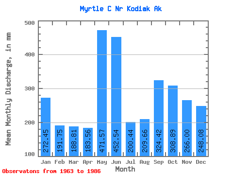
| Statistic | Jan | Feb | Mar | Apr | May | Jun | Jul | Aug | Sep | Oct | Nov | Dec | Annual |
|---|---|---|---|---|---|---|---|---|---|---|---|---|---|
| Mean | 272.37 | 193.42 | 188.81 | 183.57 | 471.61 | 452.45 | 200.37 | 209.70 | 324.45 | 308.78 | 266.10 | 248.11 | 3374.69 |
| Standard Deviation | 217.21 | 155.70 | 187.55 | 91.84 | 181.11 | 223.63 | 128.45 | 157.47 | 149.84 | 158.12 | 130.36 | 226.38 | 508.07 |
| Min | 9.33 | 12.87 | 7.63 | 20.32 | 94.45 | 90.22 | 48.29 | 25.65 | 66.43 | 123.22 | 66.48 | 19.01 | 2662.18 |
| Max | 765.34 | 448.29 | 673.31 | 368.62 | 890.05 | 1053.82 | 543.06 | 656.67 | 641.54 | 747.68 | 611.66 | 823.89 | 4539.39 |
| Coefficient of Variation | 0.80 | 0.81 | 0.99 | 0.50 | 0.38 | 0.49 | 0.64 | 0.75 | 0.46 | 0.51 | 0.49 | 0.91 | 0.15 |
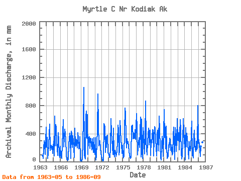
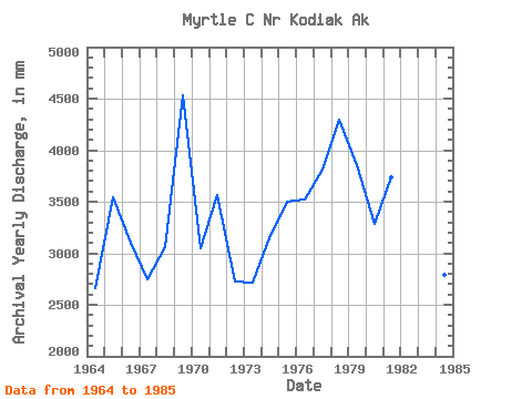
| Year | Jan | Feb | Mar | Apr | May | Jun | Jul | Aug | Sep | Oct | Nov | Dec | Annual | 1963 | 94.45 | 90.22 | 51.37 | 185.65 | 300.84 | 259.47 | 107.48 | 504.87 | 1964 | 216.54 | 324.42 | 49.35 | 126.73 | 245.42 | 531.03 | 163.09 | 230.35 | 235.65 | 179.27 | 217.59 | 122.92 | 2662.18 | 1965 | 299.90 | 80.77 | 673.31 | 227.62 | 545.97 | 481.30 | 271.09 | 95.03 | 415.45 | 311.40 | 89.90 | 65.58 | 3540.87 | 1966 | 226.21 | 82.56 | 47.32 | 247.90 | 416.08 | 598.80 | 216.66 | 351.18 | 463.65 | 333.24 | 90.86 | 36.23 | 3108.40 | 1967 | 30.52 | 19.71 | 31.16 | 245.28 | 421.88 | 336.32 | 48.29 | 449.18 | 388.65 | 207.75 | 368.60 | 203.31 | 2746.86 | 1968 | 62.85 | 448.29 | 249.88 | 216.98 | 326.83 | 200.55 | 428.04 | 337.21 | 180.87 | 211.53 | 355.15 | 19.01 | 3056.80 | 1969 | 9.33 | 12.87 | 46.68 | 285.69 | 585.29 | 1053.82 | 95.49 | 40.95 | 641.54 | 747.68 | 330.50 | 694.37 | 4539.39 | 1970 | 107.38 | 314.85 | 367.14 | 192.10 | 343.90 | 318.88 | 261.87 | 175.45 | 325.89 | 135.95 | 342.31 | 151.38 | 3051.16 | 1971 | 105.67 | 322.62 | 24.24 | 83.86 | 464.17 | 962.58 | 543.06 | 235.19 | 246.87 | 305.38 | 184.48 | 76.95 | 3570.31 | 1972 | 47.15 | 16.01 | 7.63 | 20.32 | 558.64 | 499.13 | 134.12 | 363.34 | 206.36 | 376.74 | 376.82 | 131.12 | 2725.82 | 1973 | 104.09 | 57.66 | 59.56 | 195.34 | 631.22 | 415.13 | 323.56 | 107.21 | 473.27 | 123.22 | 66.48 | 169.85 | 2720.78 | 1974 | 133.37 | 72.79 | 154.00 | 275.33 | 533.56 | 450.21 | 101.85 | 158.10 | 585.97 | 310.19 | 245.54 | 122.92 | 3145.29 | 1975 | 239.63 | 74.81 | 57.32 | 86.26 | 789.02 | 686.66 | 348.36 | 202.71 | 323.36 | 260.67 | 284.77 | 161.60 | 3504.26 | 1976 | 91.44 | 65.59 | 51.13 | 70.00 | 523.14 | 519.01 | 339.80 | 341.85 | 404.29 | 345.68 | 454.62 | 329.02 | 3525.71 | 1977 | 708.00 | 437.71 | 98.03 | 199.96 | 282.12 | 337.68 | 212.70 | 656.67 | 66.43 | 623.96 | 148.00 | 49.42 | 3818.61 | 1978 | 502.90 | 368.12 | 114.78 | 368.62 | 890.05 | 287.99 | 181.53 | 96.95 | 286.93 | 494.23 | 242.47 | 463.38 | 4294.76 | 1979 | 464.39 | 82.75 | 323.84 | 270.53 | 467.59 | 437.64 | 85.83 | 346.79 | 497.41 | 495.06 | 311.85 | 85.42 | 3857.20 | 1980 | 410.05 | 422.23 | 156.20 | 310.23 | 672.11 | 226.20 | 55.10 | 25.65 | 241.84 | 376.56 | 297.61 | 74.58 | 3285.30 | 1981 | 765.34 | 327.86 | 509.09 | 182.88 | 525.55 | 207.40 | 50.93 | 76.59 | 238.95 | 212.79 | 336.10 | 313.80 | 3742.97 | 1982 | 167.24 | 229.16 | 99.88 | 113.23 | 382.79 | 493.94 | 247.39 | 36.59 | 480.67 | 150.15 | 308.02 | 630.20 | 3346.77 | 1983 | 315.00 | 297.14 | 428.71 | 168.85 | 616.17 | 442.78 | 131.27 | 43.06 | 81.66 | 298.38 | 611.66 | 264.68 | 3704.10 | 1984 | 391.31 | 22.46 | 503.58 | 208.97 | 417.47 | 252.29 | 155.19 | 42.42 | 286.65 | 168.19 | 154.88 | 211.94 | 2796.55 | 1985 | 595.53 | 77.16 | 122.70 | 53.55 | 361.13 | 444.82 | 235.97 | 149.46 | 289.35 | 174.48 | 194.66 | 823.89 | 3499.01 | 1986 | 270.71 | 291.04 | 167.22 | 71.85 | 223.97 | 584.56 | 126.22 | 285.18 | 124.30 |
|---|
 Return to R-Arctic Net Home Page