|
|
|||||||||||||||||
| Point ID: 9487 | Downloads | Plots | Site Data | Code: 15295500 |
|
|
|||||||||||||||||
| Download | |
|---|---|
| Site Descriptor Information | Site Time Series Data |
| Link to all available data | |
|
|
| View: | Statistics | Time Series |
| Units: | m3/s |
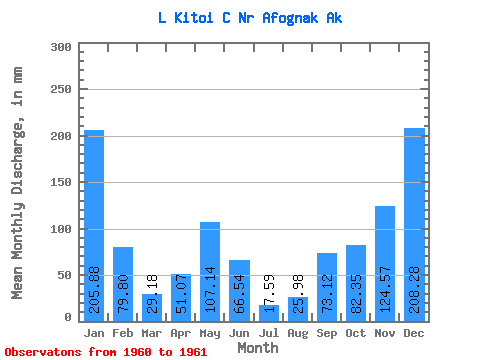
| Statistic | Jan | Feb | Mar | Apr | May | Jun | Jul | Aug | Sep | Oct | Nov | Dec | Annual |
|---|---|---|---|---|---|---|---|---|---|---|---|---|---|
| Mean | 205.85 | 80.63 | 29.05 | 50.91 | 107.02 | 66.39 | 17.59 | 25.81 | 73.07 | 82.52 | 124.75 | 208.10 | |
| Standard Deviation | |||||||||||||
| Min | 205.85 | 80.63 | 29.05 | 50.91 | 107.02 | 66.39 | 17.59 | 25.81 | 73.07 | 82.52 | 124.75 | 208.10 | |
| Max | 205.85 | 80.63 | 29.05 | 50.91 | 107.02 | 66.39 | 17.59 | 25.81 | 73.07 | 82.52 | 124.75 | 208.10 | |
| Coefficient of Variation |
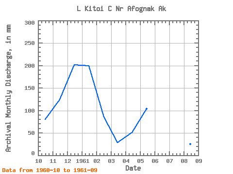
| Year | Jan | Feb | Mar | Apr | May | Jun | Jul | Aug | Sep | Oct | Nov | Dec | Annual | 1960 | 82.52 | 124.75 | 208.10 | 1961 | 205.85 | 80.63 | 29.05 | 50.91 | 107.02 | 66.39 | 17.59 | 25.81 | 73.07 |
|---|
 Return to R-Arctic Net Home Page