|
|
|||||||||||||||||
| Point ID: 9481 | Downloads | Plots | Site Data | Code: 15294410 |
|
|
|||||||||||||||||
| Download | |
|---|---|
| Site Descriptor Information | Site Time Series Data |
| Link to all available data | |
|
|
| View: | Statistics | Time Series |
| Units: | m3/s |
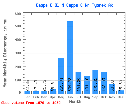
| Statistic | Jan | Feb | Mar | Apr | May | Jun | Jul | Aug | Sep | Oct | Nov | Dec | Annual |
|---|---|---|---|---|---|---|---|---|---|---|---|---|---|
| Mean | 22.31 | 17.58 | 21.73 | 38.32 | 262.96 | 534.20 | 160.95 | 131.15 | 175.85 | 163.04 | 69.01 | 25.61 | 1611.67 |
| Standard Deviation | 3.23 | 1.86 | 5.83 | 24.96 | 134.48 | 129.46 | 130.43 | 72.86 | 74.28 | 97.01 | 71.29 | 6.78 | 517.92 |
| Min | 16.74 | 15.17 | 15.90 | 16.51 | 139.31 | 408.99 | 74.33 | 46.66 | 85.62 | 89.31 | 24.66 | 17.98 | 1096.82 |
| Max | 26.00 | 20.71 | 30.66 | 80.05 | 523.87 | 764.55 | 447.97 | 217.10 | 299.89 | 347.15 | 212.19 | 35.80 | 2481.62 |
| Coefficient of Variation | 0.14 | 0.11 | 0.27 | 0.65 | 0.51 | 0.24 | 0.81 | 0.56 | 0.42 | 0.59 | 1.03 | 0.27 | 0.32 |
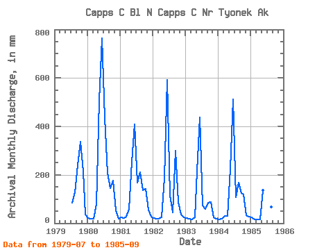
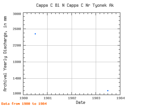
| Year | Jan | Feb | Mar | Apr | May | Jun | Jul | Aug | Sep | Oct | Nov | Dec | Annual | 1979 | 85.95 | 132.11 | 240.78 | 347.15 | 212.19 | 35.80 | 1980 | 21.54 | 17.50 | 19.64 | 80.05 | 523.87 | 764.55 | 447.97 | 215.39 | 145.44 | 182.66 | 53.87 | 18.10 | 2481.62 | 1981 | 26.00 | 20.71 | 26.78 | 57.47 | 263.32 | 408.99 | 173.48 | 217.10 | 137.61 | 147.85 | 57.04 | 28.51 | 1560.35 | 1982 | 21.51 | 17.76 | 20.65 | 23.71 | 195.24 | 591.32 | 121.00 | 46.66 | 299.89 | 89.58 | 34.52 | 25.91 | 1493.69 | 1983 | 23.51 | 17.96 | 16.74 | 23.04 | 224.20 | 436.87 | 74.33 | 61.92 | 85.62 | 89.31 | 24.66 | 17.98 | 1096.82 | 1984 | 16.74 | 16.38 | 30.66 | 29.16 | 231.85 | 512.15 | 110.27 | 173.79 | 125.31 | 121.69 | 31.79 | 27.38 | 1425.89 | 1985 | 24.54 | 15.17 | 15.90 | 16.51 | 139.31 | 491.30 | 113.62 | 71.04 | 196.27 |
|---|
 Return to R-Arctic Net Home Page