|
|
|||||||||||||||||
| Point ID: 9469 | Downloads | Plots | Site Data | Code: 15243900 |
|
|
|||||||||||||||||
| Download | |
|---|---|
| Site Descriptor Information | Site Time Series Data |
| Link to all available data | |
|
|
| View: | Statistics | Time Series |
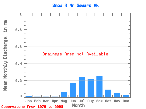
| Units: | m3/s |
| Statistic | Jan | Feb | Mar | Apr | May | Jun | Jul | Aug | Sep | Oct | Nov | Dec | Annual |
|---|---|---|---|---|---|---|---|---|---|---|---|---|---|
| Mean | |||||||||||||
| Standard Deviation | |||||||||||||
| Min | |||||||||||||
| Max | |||||||||||||
| Coefficient of Variation | 0.85 | 0.82 | 0.63 | 0.48 | 0.36 | 0.16 | 0.04 | 0.36 | 0.64 | 0.87 | 1.35 | 0.75 | 0.23 |
| Year | Jan | Feb | Mar | Apr | May | Jun | Jul | Aug | Sep | Oct | Nov | Dec | Annual | 1970 | 1974 | 1977 | 1997 | 1998 | 1999 | 2000 | 2001 | 2002 | 2003 |
|---|
 Return to R-Arctic Net Home Page