|
|
|||||||||||||||||
| Point ID: 9467 | Downloads | Plots | Site Data | Code: 15276650 |
|
|
|||||||||||||||||
| Download | |
|---|---|
| Site Descriptor Information | Site Time Series Data |
| Link to all available data | |
|
|
| View: | Statistics | Time Series |
| Units: | m3/s |
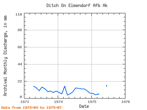
| Statistic | Jan | Feb | Mar | Apr | May | Jun | Jul | Aug | Sep | Oct | Nov | Dec | Annual |
|---|---|---|---|---|---|---|---|---|---|---|---|---|---|
| Mean | 6.88 | 4.77 | 10.95 | 39.99 | 14.74 | 11.42 | 14.88 | 12.86 | 10.29 | 10.97 | 8.54 | 8.31 | 114.82 |
| Standard Deviation | 0.85 | 0.72 | 7.51 | 52.48 | 9.56 | 3.92 | 1.26 | 0.41 | 2.14 | 1.76 | 1.69 | 2.16 | |
| Min | 6.28 | 4.26 | 5.64 | 4.33 | 5.82 | 8.61 | 13.67 | 12.57 | 8.78 | 9.73 | 7.34 | 6.78 | 114.82 |
| Max | 7.49 | 5.27 | 16.26 | 100.25 | 24.83 | 15.90 | 16.18 | 13.16 | 11.80 | 12.21 | 9.74 | 9.84 | 114.82 |
| Coefficient of Variation | 0.12 | 0.15 | 0.69 | 1.31 | 0.65 | 0.34 | 0.09 | 0.03 | 0.21 | 0.16 | 0.20 | 0.26 |
| Year | Jan | Feb | Mar | Apr | May | Jun | Jul | Aug | Sep | Oct | Nov | Dec | Annual | 1973 | 15.40 | 13.57 | 9.75 | 14.79 | 12.57 | 8.78 | 9.73 | 7.34 | 9.84 | 1974 | 7.49 | 5.27 | 16.26 | 4.33 | 5.82 | 8.61 | 13.67 | 13.16 | 11.80 | 12.21 | 9.74 | 6.78 | 114.82 | 1975 | 6.28 | 4.26 | 5.64 | 100.25 | 24.83 | 15.90 | 16.18 |
|---|
 Return to R-Arctic Net Home Page
