|
|
|||||||||||||||||
| Point ID: 9460 | Downloads | Plots | Site Data | Code: 15239060 |
|
|
|||||||||||||||||
| Download | |
|---|---|
| Site Descriptor Information | Site Time Series Data |
| Link to all available data | |
|
|
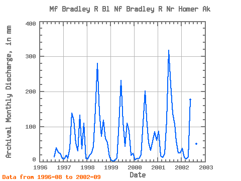
| View: | Statistics | Time Series |
| Units: | m3/s |
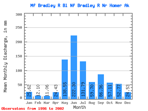
| Statistic | Jan | Feb | Mar | Apr | May | Jun | Jul | Aug | Sep | Oct | Nov | Dec | Annual |
|---|---|---|---|---|---|---|---|---|---|---|---|---|---|
| Mean | 25.61 | 12.20 | 11.06 | 24.44 | 138.53 | 222.29 | 131.76 | 59.69 | 86.35 | 57.12 | 52.77 | 24.53 | 885.10 |
| Standard Deviation | 33.78 | 5.93 | 7.21 | 12.87 | 27.08 | 70.94 | 56.10 | 40.96 | 40.18 | 21.81 | 37.75 | 20.20 | 189.45 |
| Min | 3.16 | 2.15 | 3.24 | 10.97 | 114.58 | 118.25 | 53.94 | 14.79 | 31.55 | 27.36 | 18.56 | 9.08 | 712.77 |
| Max | 88.97 | 17.99 | 24.46 | 41.65 | 182.89 | 316.91 | 227.50 | 141.97 | 132.85 | 89.09 | 110.09 | 63.25 | 1161.00 |
| Coefficient of Variation | 1.32 | 0.49 | 0.65 | 0.53 | 0.20 | 0.32 | 0.43 | 0.69 | 0.47 | 0.38 | 0.71 | 0.82 | 0.21 |
| Year | Jan | Feb | Mar | Apr | May | Jun | Jul | Aug | Sep | Oct | Nov | Dec | Annual | 1996 | 14.79 | 39.33 | 27.36 | 23.77 | 9.08 | 1997 | 8.13 | 16.81 | 9.28 | 38.43 | 142.51 | 118.25 | 53.94 | 31.97 | 132.85 | 38.48 | 110.09 | 10.13 | 712.77 | 1998 | 8.67 | 17.99 | 24.46 | 41.65 | 154.74 | 281.01 | 144.12 | 75.37 | 117.72 | 67.33 | 53.69 | 14.78 | 1001.39 | 1999 | 3.16 | 2.15 | 3.24 | 10.97 | 114.99 | 231.66 | 117.80 | 45.84 | 109.22 | 89.09 | 18.56 | 24.73 | 769.86 | 2000 | 5.44 | 9.00 | 9.41 | 19.69 | 114.58 | 201.06 | 127.56 | 55.67 | 31.55 | 60.05 | 85.36 | 63.25 | 780.47 | 2001 | 88.97 | 15.29 | 12.36 | 22.88 | 121.47 | 316.91 | 227.50 | 141.97 | 106.93 | 60.39 | 25.11 | 25.23 | 1161.00 | 2002 | 39.28 | 11.95 | 7.62 | 13.04 | 182.89 | 184.87 | 119.63 | 52.24 | 66.84 |
|---|
 Return to R-Arctic Net Home Page