|
|
|||||||||||||||||
| Point ID: 9450 | Downloads | Plots | Site Data | Code: 15274798 |
|
|
|||||||||||||||||
| Download | |
|---|---|
| Site Descriptor Information | Site Time Series Data |
| Link to all available data | |
|
|
| View: | Statistics | Time Series |
| Units: | m3/s |
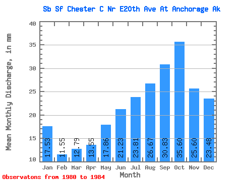
| Statistic | Jan | Feb | Mar | Apr | May | Jun | Jul | Aug | Sep | Oct | Nov | Dec | Annual |
|---|---|---|---|---|---|---|---|---|---|---|---|---|---|
| Mean | 17.49 | 11.64 | 12.75 | 13.50 | 17.83 | 21.21 | 23.80 | 26.69 | 30.86 | 35.58 | 25.60 | 23.42 | 257.56 |
| Standard Deviation | 6.98 | 3.58 | 2.13 | 1.01 | 3.36 | 3.97 | 2.84 | 10.56 | 11.38 | 9.71 | 6.61 | 5.80 | 39.18 |
| Min | 9.96 | 8.54 | 9.91 | 12.20 | 13.97 | 16.25 | 20.17 | 19.43 | 20.62 | 21.43 | 18.43 | 15.96 | 219.19 |
| Max | 25.29 | 15.17 | 15.07 | 14.43 | 21.84 | 25.96 | 26.78 | 42.35 | 44.92 | 43.27 | 31.25 | 29.45 | 297.51 |
| Coefficient of Variation | 0.40 | 0.31 | 0.17 | 0.07 | 0.19 | 0.19 | 0.12 | 0.40 | 0.37 | 0.27 | 0.26 | 0.25 | 0.15 |
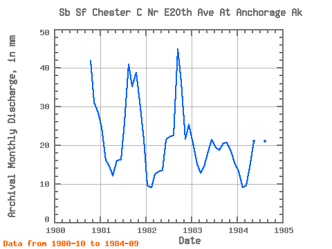
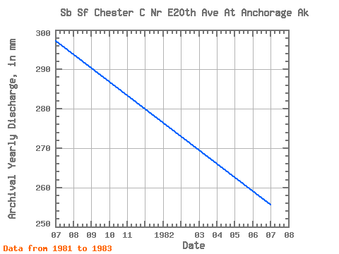
| Year | Jan | Feb | Mar | Apr | May | Jun | Jul | Aug | Sep | Oct | Nov | Dec | Annual | 1980 | 43.27 | 31.19 | 29.45 | 1981 | 25.29 | 15.17 | 15.07 | 12.20 | 16.54 | 16.25 | 26.78 | 42.35 | 35.22 | 40.02 | 31.25 | 22.13 | 297.51 | 1982 | 9.96 | 8.54 | 12.82 | 13.23 | 13.97 | 21.33 | 23.14 | 23.31 | 44.92 | 37.59 | 21.53 | 26.14 | 255.99 | 1983 | 21.14 | 14.29 | 13.20 | 14.43 | 18.97 | 21.29 | 20.17 | 19.43 | 20.62 | 21.43 | 18.43 | 15.96 | 219.19 | 1984 | 13.55 | 8.58 | 9.91 | 14.14 | 21.84 | 25.96 | 25.13 | 21.67 | 22.69 |
|---|
 Return to R-Arctic Net Home Page