|
|
|||||||||||||||||
| Point ID: 9439 | Downloads | Plots | Site Data | Code: 15272380 |
|
|
|||||||||||||||||
| Download | |
|---|---|
| Site Descriptor Information | Site Time Series Data |
| Link to all available data | |
|
|
| View: | Statistics | Time Series |
| Units: | m3/s |
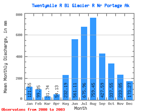
| Statistic | Jan | Feb | Mar | Apr | May | Jun | Jul | Aug | Sep | Oct | Nov | Dec | Annual |
|---|---|---|---|---|---|---|---|---|---|---|---|---|---|
| Mean | 121.53 | 100.20 | 31.74 | 54.13 | 232.16 | 561.11 | 675.86 | 759.34 | 427.60 | 337.50 | 233.85 | 173.25 | 3853.16 |
| Standard Deviation | 44.01 | 107.79 | 22.24 | 26.54 | 61.34 | 55.16 | 98.74 | 197.54 | 99.24 | 231.46 | 232.21 | 20.90 | |
| Min | 90.41 | 23.99 | 16.01 | 24.34 | 164.94 | 504.99 | 580.68 | 560.64 | 324.51 | 157.40 | 88.93 | 158.47 | 3853.16 |
| Max | 152.65 | 176.42 | 47.46 | 75.29 | 285.12 | 615.26 | 777.80 | 955.71 | 522.48 | 598.56 | 501.68 | 188.03 | 3853.16 |
| Coefficient of Variation | 0.36 | 1.08 | 0.70 | 0.49 | 0.26 | 0.10 | 0.15 | 0.26 | 0.23 | 0.69 | 0.99 | 0.12 |
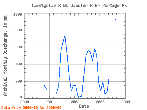
| Year | Jan | Feb | Mar | Apr | May | Jun | Jul | Aug | Sep | Oct | Nov | Dec | Annual | 2000 | 157.40 | 110.94 | 2001 | 62.74 | 164.94 | 563.07 | 669.09 | 761.66 | 522.48 | 256.55 | 88.93 | 158.47 | 2002 | 152.65 | 23.99 | 16.01 | 24.34 | 285.12 | 504.99 | 580.68 | 560.64 | 435.80 | 598.56 | 501.68 | 188.03 | 3853.16 | 2003 | 90.41 | 176.42 | 47.46 | 75.29 | 246.40 | 615.26 | 777.80 | 955.71 | 324.51 |
|---|
 Return to R-Arctic Net Home Page