|
|
|||||||||||||||||
| Point ID: 9425 | Downloads | Plots | Site Data | Code: 15564877 |
|
|
|||||||||||||||||
| Download | |
|---|---|
| Site Descriptor Information | Site Time Series Data |
| Link to all available data | |
|
|
| View: | Statistics | Time Series |
| Units: | m3/s |
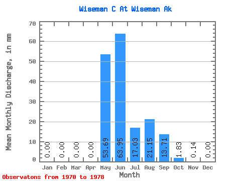
| Statistic | Jan | Feb | Mar | Apr | May | Jun | Jul | Aug | Sep | Oct | Nov | Dec | Annual |
|---|---|---|---|---|---|---|---|---|---|---|---|---|---|
| Mean | 0.00 | 0.00 | 0.00 | 0.00 | 53.70 | 63.94 | 17.03 | 21.15 | 13.72 | 1.84 | 0.14 | 0.00 | 177.57 |
| Standard Deviation | 0.00 | 0.00 | 0.00 | 0.00 | 33.52 | 26.35 | 9.82 | 16.60 | 6.46 | 2.00 | 0.17 | 0.00 | 66.76 |
| Min | 0.00 | 0.00 | 0.00 | 0.00 | 21.22 | 29.83 | 4.48 | 5.61 | 5.91 | 0.00 | 0.00 | 0.00 | 102.25 |
| Max | 0.00 | 0.00 | 0.00 | 0.00 | 122.75 | 113.15 | 30.94 | 60.73 | 22.55 | 4.51 | 0.38 | 0.00 | 305.59 |
| Coefficient of Variation | 0.62 | 0.41 | 0.58 | 0.79 | 0.47 | 1.09 | 1.17 | 0.38 |
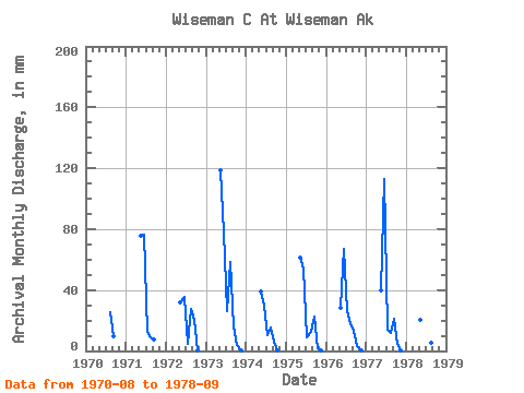
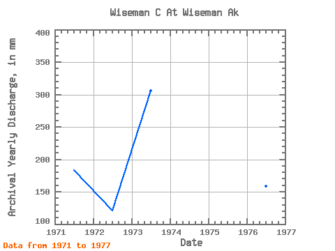
| Year | Jan | Feb | Mar | Apr | May | Jun | Jul | Aug | Sep | Oct | Nov | Dec | Annual | 1970 | 26.27 | 9.64 | 0.00 | 0.00 | 0.00 | 1971 | 0.00 | 0.00 | 0.00 | 0.00 | 78.36 | 76.09 | 13.18 | 9.08 | 7.76 | 0.00 | 0.00 | 0.00 | 183.90 | 1972 | 0.00 | 0.00 | 0.00 | 0.00 | 33.05 | 35.59 | 4.48 | 28.35 | 20.18 | 0.27 | 0.00 | 0.00 | 121.54 | 1973 | 0.00 | 0.00 | 0.00 | 0.00 | 122.75 | 77.47 | 26.80 | 60.73 | 15.82 | 4.09 | 0.38 | 0.00 | 305.59 | 1974 | 0.00 | 0.00 | 0.00 | 0.00 | 40.34 | 29.83 | 10.66 | 16.17 | 5.91 | 0.03 | 0.00 | 0.00 | 102.25 | 1975 | 0.00 | 0.00 | 0.00 | 0.00 | 63.04 | 53.77 | 8.96 | 12.92 | 22.55 | 2.15 | 0.14 | 0.00 | 163.09 | 1976 | 0.00 | 0.00 | 0.00 | 0.00 | 29.34 | 66.87 | 27.03 | 18.68 | 12.93 | 3.65 | 0.33 | 0.00 | 158.59 | 1977 | 0.00 | 0.00 | 0.00 | 0.00 | 41.46 | 113.15 | 14.21 | 12.52 | 21.24 | 4.51 | 0.28 | 0.00 | 208.04 | 1978 | 0.00 | 0.00 | 0.00 | 0.00 | 21.22 | 58.77 | 30.94 | 5.61 | 7.47 |
|---|
 Return to R-Arctic Net Home Page