|
|
|||||||||||||||||
| Point ID: 9399 | Downloads | Plots | Site Data | Code: 15904800 |
|
|
|||||||||||||||||
| Download | |
|---|---|
| Site Descriptor Information | Site Time Series Data |
| Link to all available data | |
|
|
| View: | Statistics | Time Series |
| Units: | m3/s |
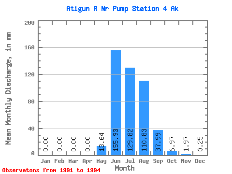
| Statistic | Jan | Feb | Mar | Apr | May | Jun | Jul | Aug | Sep | Oct | Nov | Dec | Annual |
|---|---|---|---|---|---|---|---|---|---|---|---|---|---|
| Mean | 0.00 | 0.00 | 0.00 | 0.00 | 13.64 | 155.93 | 129.81 | 110.81 | 37.98 | 6.96 | 1.97 | 0.25 | 418.32 |
| Standard Deviation | 0.00 | 0.00 | 0.00 | 0.00 | 2.12 | 5.65 | 67.40 | 13.63 | 17.64 | 4.25 | 0.77 | 0.22 | 49.89 |
| Min | 0.00 | 0.00 | 0.00 | 0.00 | 11.56 | 149.45 | 71.55 | 96.03 | 20.61 | 3.86 | 1.08 | 0.10 | 383.04 |
| Max | 0.00 | 0.00 | 0.00 | 0.00 | 15.79 | 159.89 | 203.62 | 122.89 | 55.88 | 11.81 | 2.48 | 0.50 | 453.60 |
| Coefficient of Variation | 0.15 | 0.04 | 0.52 | 0.12 | 0.47 | 0.61 | 0.39 | 0.88 | 0.12 |
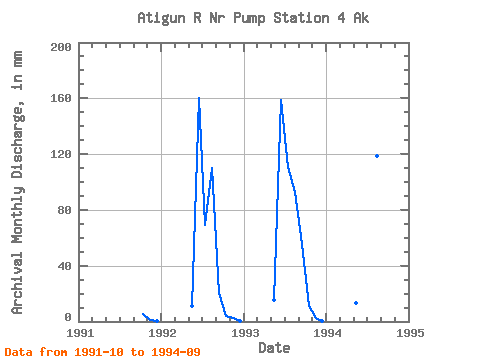
| Year | Jan | Feb | Mar | Apr | May | Jun | Jul | Aug | Sep | Oct | Nov | Dec | Annual | 1991 | 5.22 | 1.08 | 0.10 | 1992 | 0.00 | 0.00 | 0.00 | 0.00 | 11.56 | 159.89 | 71.55 | 113.50 | 20.61 | 3.86 | 2.48 | 0.50 | 383.04 | 1993 | 0.00 | 0.00 | 0.00 | 0.00 | 15.79 | 158.44 | 114.26 | 96.03 | 55.88 | 11.81 | 2.33 | 0.15 | 453.60 | 1994 | 0.00 | 0.00 | 0.00 | 0.00 | 13.56 | 149.45 | 203.62 | 122.89 | 37.45 |
|---|
 Return to R-Arctic Net Home Page