|
|
|||||||||||||||||
| Point ID: 9379 | Downloads | Plots | Site Data | Code: 15300300 |
|
|
|||||||||||||||||
| Download | |
|---|---|
| Site Descriptor Information | Site Time Series Data |
| Link to all available data | |
|
|
| View: | Statistics | Time Series |
| Units: | m3/s |
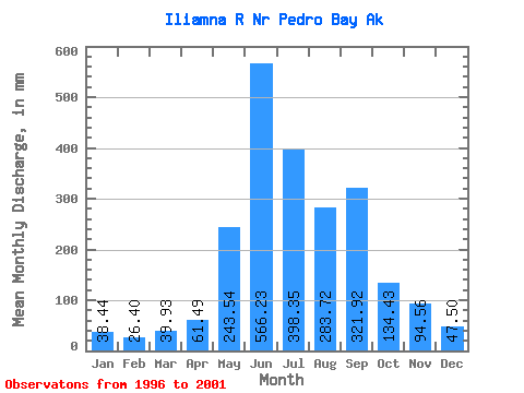
| Statistic | Jan | Feb | Mar | Apr | May | Jun | Jul | Aug | Sep | Oct | Nov | Dec | Annual |
|---|---|---|---|---|---|---|---|---|---|---|---|---|---|
| Mean | 38.44 | 26.63 | 39.93 | 61.49 | 243.51 | 566.23 | 398.29 | 283.67 | 321.92 | 134.41 | 94.56 | 47.49 | 2324.02 |
| Standard Deviation | 31.47 | 16.78 | 31.58 | 34.90 | 64.83 | 175.50 | 187.35 | 88.91 | 162.00 | 53.73 | 57.45 | 29.18 | 586.07 |
| Min | 17.19 | 12.84 | 13.87 | 19.45 | 172.13 | 379.88 | 180.36 | 158.31 | 138.82 | 66.14 | 35.72 | 19.33 | 1726.97 |
| Max | 91.51 | 52.70 | 93.00 | 110.79 | 333.70 | 839.21 | 670.48 | 373.03 | 482.18 | 196.99 | 165.52 | 94.27 | 3124.91 |
| Coefficient of Variation | 0.82 | 0.63 | 0.79 | 0.57 | 0.27 | 0.31 | 0.47 | 0.31 | 0.50 | 0.40 | 0.61 | 0.61 | 0.25 |
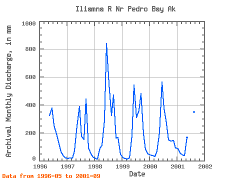
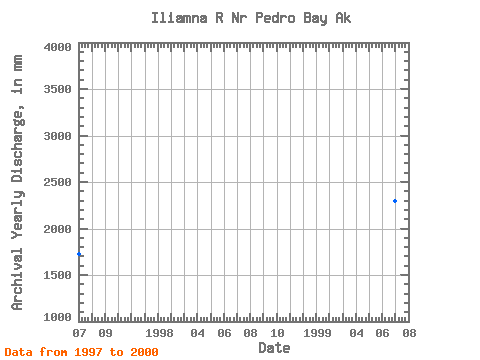
| Year | Jan | Feb | Mar | Apr | May | Jun | Jul | Aug | Sep | Oct | Nov | Dec | Annual | 1996 | 333.70 | 379.88 | 262.65 | 198.18 | 138.82 | 66.14 | 35.72 | 19.33 | 1997 | 18.02 | 19.75 | 18.89 | 70.21 | 257.73 | 389.39 | 180.36 | 158.31 | 441.84 | 94.27 | 48.93 | 27.34 | 1726.97 | 1998 | 17.19 | 12.84 | 93.00 | 110.79 | 300.36 | 839.21 | 568.94 | 334.25 | 470.98 | 169.75 | 165.52 | 45.23 | 3124.91 | 1999 | 22.43 | 14.07 | 13.87 | 19.45 | 186.07 | 544.52 | 318.95 | 373.03 | 482.18 | 196.99 | 79.20 | 51.29 | 2298.80 | 2000 | 43.02 | 33.78 | 32.84 | 68.84 | 211.08 | 564.15 | 388.38 | 277.65 | 148.25 | 144.91 | 143.42 | 94.27 | 2145.41 | 2001 | 91.51 | 52.70 | 41.03 | 38.16 | 172.13 | 680.24 | 670.48 | 360.62 | 249.45 |
|---|
 Return to R-Arctic Net Home Page