|
|
|||||||||||||||||
| Point ID: 9335 | Downloads | Plots | Site Data | Code: 15297470 |
|
|
|||||||||||||||||
| Download | |
|---|---|
| Site Descriptor Information | Site Time Series Data |
| Link to all available data | |
|
|
| View: | Statistics | Time Series |
| Units: | m3/s |
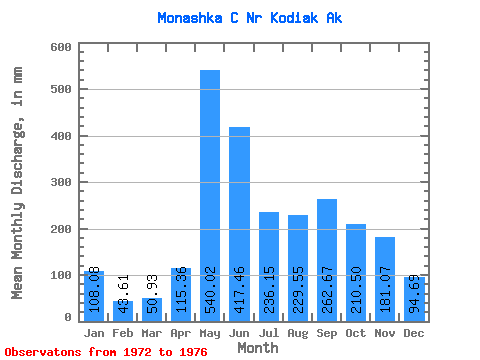
| Statistic | Jan | Feb | Mar | Apr | May | Jun | Jul | Aug | Sep | Oct | Nov | Dec | Annual |
|---|---|---|---|---|---|---|---|---|---|---|---|---|---|
| Mean | 108.11 | 44.05 | 50.92 | 115.31 | 539.89 | 417.37 | 236.19 | 229.50 | 262.73 | 210.44 | 181.08 | 94.75 | 2417.72 |
| Standard Deviation | 62.83 | 6.46 | 40.74 | 60.52 | 50.32 | 140.56 | 87.04 | 150.69 | 156.72 | 101.54 | 111.15 | 11.78 | 412.15 |
| Min | 70.24 | 36.61 | 8.96 | 61.06 | 486.32 | 226.59 | 137.11 | 74.89 | 97.80 | 71.53 | 39.12 | 83.01 | 1946.31 |
| Max | 202.10 | 50.20 | 106.13 | 174.30 | 607.24 | 579.94 | 318.72 | 428.43 | 438.13 | 307.49 | 286.36 | 106.52 | 2709.95 |
| Coefficient of Variation | 0.58 | 0.15 | 0.80 | 0.53 | 0.09 | 0.34 | 0.37 | 0.66 | 0.60 | 0.48 | 0.61 | 0.12 | 0.17 |
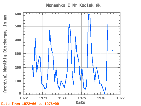
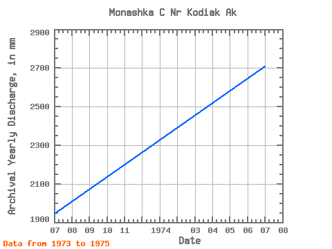
| Year | Jan | Feb | Mar | Apr | May | Jun | Jul | Aug | Sep | Oct | Nov | Dec | Annual | 1972 | 226.59 | 137.11 | 428.43 | 165.50 | 257.28 | 286.36 | 83.01 | 1973 | 70.24 | 40.74 | 50.71 | 160.66 | 486.32 | 327.02 | 309.86 | 101.51 | 189.79 | 71.53 | 39.12 | 106.52 | 1946.31 | 1974 | 80.10 | 48.66 | 106.13 | 174.30 | 539.90 | 454.17 | 150.12 | 74.89 | 422.44 | 307.49 | 250.17 | 103.10 | 2709.95 | 1975 | 202.10 | 50.20 | 37.90 | 65.24 | 607.24 | 579.94 | 318.72 | 210.19 | 97.80 | 205.46 | 148.67 | 86.37 | 2596.89 | 1976 | 80.00 | 36.61 | 8.96 | 61.06 | 526.10 | 499.14 | 265.16 | 332.48 | 438.13 |
|---|
 Return to R-Arctic Net Home Page