|
|
|||||||||||||||||
| Point ID: 9332 | Downloads | Plots | Site Data | Code: 15054600 |
|
|
|||||||||||||||||
| Download | |
|---|---|
| Site Descriptor Information | Site Time Series Data |
| Link to all available data | |
|
|
| View: | Statistics | Time Series |
| Units: | m3/s |
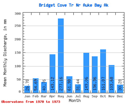
| Statistic | Jan | Feb | Mar | Apr | May | Jun | Jul | Aug | Sep | Oct | Nov | Dec | Annual |
|---|---|---|---|---|---|---|---|---|---|---|---|---|---|
| Mean | 26.42 | 54.96 | 41.02 | 142.62 | 277.06 | 62.13 | 31.44 | 148.57 | 136.47 | 161.63 | 103.28 | 29.72 | 1213.81 |
| Standard Deviation | 14.60 | 56.08 | 12.54 | 57.89 | 112.01 | 22.00 | 11.23 | 38.46 | 25.76 | 65.45 | 24.22 | 10.38 | 122.36 |
| Min | 11.57 | 9.88 | 28.88 | 76.03 | 211.46 | 46.77 | 23.29 | 110.05 | 112.73 | 87.63 | 77.80 | 21.90 | 1127.28 |
| Max | 40.75 | 117.76 | 53.94 | 180.95 | 406.39 | 87.34 | 44.24 | 186.97 | 163.86 | 211.91 | 125.99 | 41.50 | 1300.34 |
| Coefficient of Variation | 0.55 | 1.02 | 0.31 | 0.41 | 0.40 | 0.35 | 0.36 | 0.26 | 0.19 | 0.41 | 0.23 | 0.35 | 0.10 |
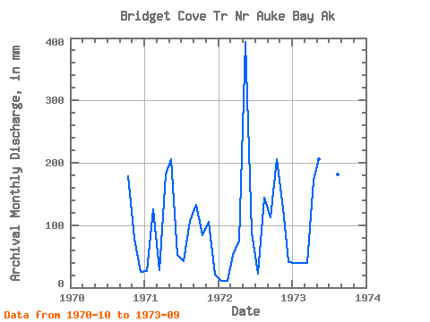
| Year | Jan | Feb | Mar | Apr | May | Jun | Jul | Aug | Sep | Oct | Nov | Dec | Annual | 1970 | 185.36 | 77.80 | 25.77 | 1971 | 26.93 | 117.76 | 28.88 | 180.95 | 211.46 | 52.29 | 44.24 | 110.05 | 132.83 | 87.63 | 106.05 | 21.90 | 1127.28 | 1972 | 11.57 | 9.88 | 53.94 | 76.03 | 406.39 | 87.34 | 23.29 | 148.70 | 112.73 | 211.91 | 125.99 | 41.50 | 1300.34 | 1973 | 40.75 | 37.24 | 40.23 | 170.88 | 213.34 | 46.77 | 26.78 | 186.97 | 163.86 |
|---|
 Return to R-Arctic Net Home Page