|
|
|||||||||||||||||
| Point ID: 9331 | Downloads | Plots | Site Data | Code: 15070000 |
|
|
|||||||||||||||||
| Download | |
|---|---|
| Site Descriptor Information | Site Time Series Data |
| Link to all available data | |
|
|
| View: | Statistics | Time Series |
| Units: | m3/s |
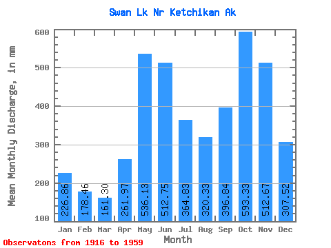
| Statistic | Jan | Feb | Mar | Apr | May | Jun | Jul | Aug | Sep | Oct | Nov | Dec | Annual |
|---|---|---|---|---|---|---|---|---|---|---|---|---|---|
| Mean | 226.83 | 179.99 | 161.26 | 261.96 | 536.06 | 512.74 | 364.77 | 320.29 | 396.83 | 593.25 | 512.67 | 307.49 | 4395.70 |
| Standard Deviation | 166.07 | 137.21 | 91.58 | 106.40 | 114.88 | 112.04 | 110.43 | 147.41 | 175.35 | 208.66 | 252.95 | 198.05 | 528.97 |
| Min | 30.86 | 29.85 | 46.54 | 97.03 | 324.30 | 259.49 | 104.88 | 99.01 | 93.93 | 205.53 | 141.10 | 92.95 | 3140.84 |
| Max | 785.61 | 694.77 | 394.22 | 508.94 | 762.34 | 755.70 | 579.30 | 588.10 | 797.25 | 1101.03 | 1398.04 | 906.34 | 5339.27 |
| Coefficient of Variation | 0.73 | 0.76 | 0.57 | 0.41 | 0.21 | 0.22 | 0.30 | 0.46 | 0.44 | 0.35 | 0.49 | 0.64 | 0.12 |
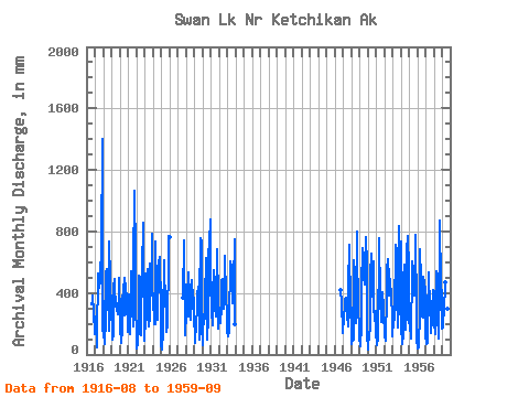
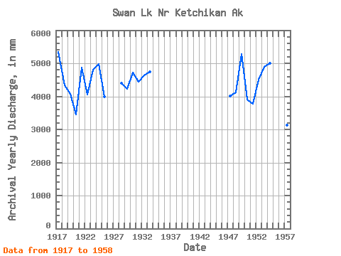
| Year | Jan | Feb | Mar | Apr | May | Jun | Jul | Aug | Sep | Oct | Nov | Dec | Annual | 1916 | 336.13 | 339.29 | 398.23 | 274.51 | 137.71 | 1917 | 134.42 | 233.55 | 47.50 | 164.11 | 489.03 | 529.60 | 447.95 | 495.27 | 528.87 | 698.14 | 1398.04 | 160.49 | 5339.27 | 1918 | 361.11 | 131.61 | 72.22 | 225.24 | 544.12 | 556.27 | 347.06 | 426.44 | 156.12 | 758.95 | 474.45 | 301.31 | 4335.45 | 1919 | 350.60 | 87.74 | 133.08 | 443.83 | 504.95 | 423.84 | 340.49 | 293.80 | 310.88 | 272.84 | 414.49 | 512.15 | 4075.71 | 1920 | 230.18 | 162.94 | 79.81 | 163.75 | 324.30 | 458.09 | 259.52 | 513.45 | 281.42 | 478.96 | 331.26 | 181.80 | 3459.22 | 1921 | 148.82 | 370.20 | 137.71 | 137.60 | 349.87 | 539.85 | 306.77 | 185.24 | 581.15 | 1101.03 | 641.97 | 365.12 | 4875.51 | 1922 | 95.47 | 39.56 | 77.48 | 177.50 | 528.90 | 501.56 | 250.77 | 131.78 | 621.35 | 562.11 | 855.50 | 211.98 | 4055.34 | 1923 | 93.47 | 227.39 | 230.59 | 508.94 | 576.25 | 409.55 | 192.45 | 251.48 | 594.29 | 396.36 | 783.76 | 531.82 | 4807.02 | 1924 | 296.63 | 347.17 | 202.14 | 195.10 | 762.34 | 419.41 | 374.04 | 231.81 | 573.61 | 620.51 | 636.89 | 313.48 | 4976.72 | 1925 | 65.60 | 29.85 | 161.55 | 227.18 | 633.59 | 465.24 | 452.40 | 182.23 | 149.38 | 205.53 | 632.59 | 797.39 | 3981.67 | 1926 | 785.61 | 1927 | 372.04 | 763.32 | 141.10 | 131.14 | 1928 | 473.04 | 190.32 | 394.22 | 249.06 | 550.93 | 386.74 | 329.92 | 233.08 | 360.38 | 502.96 | 356.99 | 383.37 | 4394.26 | 1929 | 284.36 | 73.87 | 244.21 | 144.05 | 360.80 | 413.07 | 341.76 | 575.29 | 93.93 | 779.47 | 737.03 | 200.72 | 4224.70 | 1930 | 63.97 | 247.39 | 204.73 | 264.51 | 366.15 | 628.78 | 297.98 | 99.01 | 246.57 | 661.36 | 730.04 | 906.34 | 4716.92 | 1931 | 490.33 | 267.10 | 199.37 | 388.50 | 568.25 | 404.32 | 311.38 | 257.54 | 333.10 | 709.30 | 343.40 | 173.64 | 4440.00 | 1932 | 314.56 | 284.49 | 212.08 | 304.96 | 497.94 | 491.80 | 447.50 | 310.99 | 642.87 | 474.65 | 506.45 | 143.28 | 4639.20 | 1933 | 198.03 | 109.44 | 154.95 | 261.05 | 569.48 | 603.13 | 579.30 | 523.98 | 333.69 | 477.39 | 747.62 | 200.61 | 4747.24 | 1946 | 436.18 | 337.32 | 142.37 | 1947 | 174.11 | 205.37 | 350.29 | 361.91 | 376.69 | 372.55 | 264.09 | 187.91 | 450.92 | 734.95 | 296.18 | 249.77 | 4020.55 | 1948 | 315.24 | 64.06 | 102.07 | 97.03 | 631.61 | 534.41 | 277.69 | 210.27 | 797.25 | 634.62 | 375.71 | 92.95 | 4123.77 | 1949 | 138.85 | 49.75 | 196.47 | 481.16 | 665.71 | 694.11 | 519.08 | 471.07 | 568.62 | 791.79 | 583.53 | 136.34 | 5282.15 | 1950 | 30.86 | 74.84 | 104.81 | 192.21 | 533.33 | 654.85 | 477.34 | 387.15 | 604.78 | 334.73 | 218.43 | 291.61 | 3896.52 | 1951 | 159.72 | 60.32 | 112.24 | 222.68 | 639.77 | 755.70 | 388.27 | 221.50 | 212.19 | 419.35 | 303.22 | 291.63 | 3773.15 | 1952 | 117.39 | 186.01 | 92.98 | 389.02 | 568.56 | 623.58 | 514.57 | 399.57 | 472.88 | 510.19 | 371.80 | 271.23 | 4515.15 | 1953 | 119.59 | 215.22 | 235.72 | 252.50 | 734.69 | 444.37 | 401.90 | 183.82 | 552.69 | 859.54 | 513.42 | 388.16 | 4891.82 | 1954 | 136.86 | 694.77 | 69.71 | 126.18 | 507.05 | 586.12 | 370.39 | 169.66 | 278.36 | 696.09 | 767.45 | 570.34 | 5007.67 | 1955 | 221.09 | 180.31 | 107.32 | 262.37 | 424.53 | 603.31 | 484.00 | 588.10 | 384.49 | 802.62 | 271.84 | 103.59 | 4420.95 | 1956 | 44.45 | 81.36 | 46.54 | 276.99 | 704.04 | 486.81 | 255.10 | 425.10 | 238.99 | 525.56 | 466.50 | 434.24 | 3969.91 | 1957 | 130.65 | 64.03 | 75.04 | 230.03 | 551.68 | 475.78 | 363.24 | 147.32 | 206.81 | 291.60 | 417.08 | 194.56 | 3140.84 | 1958 | 426.34 | 194.90 | 140.72 | 318.45 | 561.83 | 259.49 | 104.88 | 541.22 | 289.73 | 899.20 | 451.59 | 405.43 | 4573.10 | 1959 | 176.72 | 166.23 | 329.79 | 269.07 | 483.24 | 634.43 | 513.86 | 308.09 | 328.31 |
|---|
 Return to R-Arctic Net Home Page