|
|
|||||||||||||||||
| Point ID: 9323 | Downloads | Plots | Site Data | Code: 15058000 |
|
|
|||||||||||||||||
| Download | |
|---|---|
| Site Descriptor Information | Site Time Series Data |
| Link to all available data | |
|
|
| View: | Statistics | Time Series |
| Units: | m3/s |
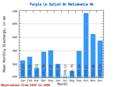
| Statistic | Jan | Feb | Mar | Apr | May | Jun | Jul | Aug | Sep | Oct | Nov | Dec | Annual |
|---|---|---|---|---|---|---|---|---|---|---|---|---|---|
| Mean | 327.92 | 357.25 | 271.23 | 391.77 | 404.16 | 302.36 | 208.11 | 248.66 | 397.07 | 679.49 | 523.41 | 475.17 | 4627.17 |
| Standard Deviation | 202.19 | 218.53 | 93.26 | 182.34 | 90.08 | 122.73 | 100.47 | 174.07 | 168.72 | 216.26 | 225.59 | 256.61 | 828.34 |
| Min | 24.70 | 102.10 | 120.87 | 145.81 | 267.39 | 84.09 | 79.72 | 50.59 | 145.00 | 348.80 | 312.57 | 216.06 | 3267.22 |
| Max | 623.65 | 799.83 | 465.33 | 790.23 | 545.90 | 440.52 | 391.39 | 489.80 | 683.09 | 918.73 | 876.84 | 1006.59 | 5652.66 |
| Coefficient of Variation | 0.62 | 0.61 | 0.34 | 0.47 | 0.22 | 0.41 | 0.48 | 0.70 | 0.42 | 0.32 | 0.43 | 0.54 | 0.18 |
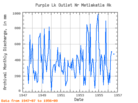
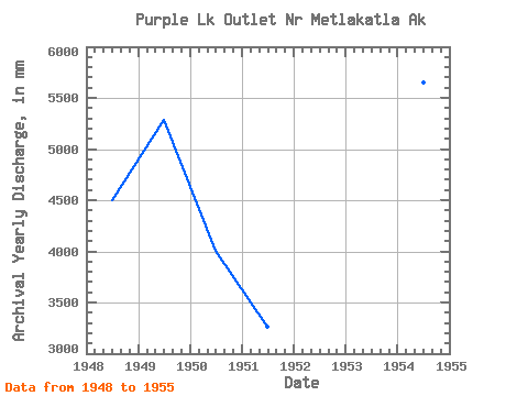
| Year | Jan | Feb | Mar | Apr | May | Jun | Jul | Aug | Sep | Oct | Nov | Dec | Annual | 1947 | 332.13 | 109.61 | 357.56 | 739.63 | 351.51 | 508.36 | 1948 | 623.65 | 221.97 | 274.15 | 145.81 | 267.39 | 179.28 | 121.59 | 147.76 | 683.09 | 719.65 | 735.10 | 382.69 | 4499.54 | 1949 | 487.27 | 102.10 | 291.86 | 790.23 | 400.10 | 390.19 | 261.18 | 417.54 | 496.77 | 841.41 | 599.42 | 216.06 | 5283.21 | 1950 | 24.70 | 229.33 | 303.67 | 337.18 | 357.80 | 246.22 | 391.39 | 391.38 | 555.97 | 348.80 | 312.57 | 508.37 | 4004.84 | 1951 | 356.11 | 237.26 | 279.62 | 219.92 | 353.58 | 429.28 | 79.72 | 115.28 | 145.00 | 407.84 | 316.40 | 326.90 | 3267.22 | 1952 | 305.05 | 357.45 | 283.35 | 421.87 | 326.90 | 254.55 | 174.53 | 196.43 | 464.01 | 458.73 | 408.46 | 350.21 | 4014.53 | 1953 | 223.11 | 546.71 | 465.33 | 376.70 | 545.90 | 84.09 | 203.93 | 91.91 | 481.72 | 870.93 | 778.27 | 742.17 | 5422.27 | 1954 | 271.93 | 799.83 | 197.55 | 323.25 | 429.76 | 399.03 | 219.01 | 50.59 | 232.97 | 809.65 | 876.84 | 1006.59 | 5652.66 | 1955 | 560.81 | 494.65 | 224.67 | 466.96 | 433.98 | 298.08 | 90.50 | 476.35 | 334.22 | 918.73 | 332.12 | 235.17 | 4873.07 | 1956 | 98.61 | 225.95 | 120.87 | 444.02 | 521.99 | 440.52 | 207.16 | 489.80 | 219.36 |
|---|
 Return to R-Arctic Net Home Page