|
|
|||||||||||||||||
| Point ID: 9321 | Downloads | Plots | Site Data | Code: 15057580 |
|
|
|||||||||||||||||
| Download | |
|---|---|
| Site Descriptor Information | Site Time Series Data |
| Link to all available data | |
|
|
| View: | Statistics | Time Series |
| Units: | m3/s |
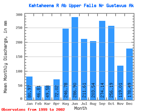
| Statistic | Jan | Feb | Mar | Apr | May | Jun | Jul | Aug | Sep | Oct | Nov | Dec | Annual |
|---|---|---|---|---|---|---|---|---|---|---|---|---|---|
| Mean | 80.94 | 47.18 | 49.57 | 72.06 | 246.77 | 286.94 | 211.58 | 203.50 | 274.12 | 256.17 | 118.97 | 178.51 | 1780.97 |
| Standard Deviation | 32.32 | 16.56 | 21.56 | 31.98 | 72.77 | 32.99 | 29.22 | 127.21 | 62.60 | 81.93 | 48.36 | 167.21 | 298.07 |
| Min | 54.06 | 29.14 | 25.11 | 42.50 | 167.50 | 253.16 | 177.85 | 77.21 | 217.19 | 195.98 | 63.78 | 59.59 | 1570.20 |
| Max | 116.80 | 61.69 | 65.81 | 106.00 | 310.54 | 319.09 | 228.96 | 380.46 | 357.75 | 349.47 | 153.90 | 369.71 | 1991.74 |
| Coefficient of Variation | 0.40 | 0.35 | 0.43 | 0.44 | 0.29 | 0.12 | 0.14 | 0.62 | 0.23 | 0.32 | 0.41 | 0.94 | 0.17 |
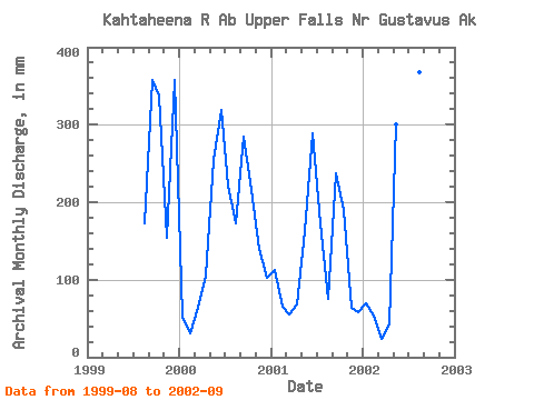
| Year | Jan | Feb | Mar | Apr | May | Jun | Jul | Aug | Sep | Oct | Nov | Dec | Annual | 1999 | 178.00 | 357.75 | 349.47 | 153.90 | 369.71 | 2000 | 54.06 | 29.14 | 65.81 | 106.00 | 262.27 | 319.09 | 228.96 | 178.33 | 284.90 | 223.05 | 139.24 | 106.25 | 1991.74 | 2001 | 116.80 | 61.69 | 57.79 | 67.68 | 167.50 | 288.56 | 177.85 | 77.21 | 236.62 | 195.98 | 63.78 | 59.59 | 1570.20 | 2002 | 71.95 | 50.71 | 25.11 | 42.50 | 310.54 | 253.16 | 227.94 | 380.46 | 217.19 |
|---|
 Return to R-Arctic Net Home Page