|
|
|||||||||||||||||
| Point ID: 9317 | Downloads | Plots | Site Data | Code: 15056210 |
|
|
|||||||||||||||||
| Download | |
|---|---|
| Site Descriptor Information | Site Time Series Data |
| Link to all available data | |
|
|
| View: | Statistics | Time Series |
| Units: | m3/s |
| Statistic | Jan | Feb | Mar | Apr | May | Jun | Jul | Aug | Sep | Oct | Nov | Dec | Annual |
|---|---|---|---|---|---|---|---|---|---|---|---|---|---|
| Mean | 13.57 | 14.26 | 11.95 | 20.32 | 113.17 | 323.09 | 577.56 | 569.70 | 325.41 | 126.09 | 58.18 | 23.75 | 2104.20 |
| Standard Deviation | 4.93 | 6.88 | 5.41 | 8.83 | 18.09 | 61.02 | 131.86 | 120.93 | 111.47 | 59.02 | 48.52 | 15.54 | 238.22 |
| Min | 5.45 | 7.36 | 4.53 | 8.47 | 73.86 | 257.27 | 423.97 | 444.65 | 192.30 | 72.61 | 8.14 | 8.87 | 1642.94 |
| Max | 18.37 | 28.43 | 22.80 | 34.74 | 133.50 | 418.86 | 745.52 | 781.30 | 495.75 | 251.03 | 127.43 | 53.93 | 2288.38 |
| Coefficient of Variation | 0.36 | 0.48 | 0.45 | 0.43 | 0.16 | 0.19 | 0.23 | 0.21 | 0.34 | 0.47 | 0.83 | 0.65 | 0.11 |
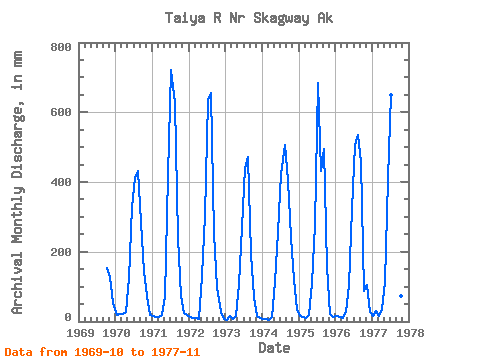
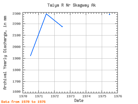
| Year | Jan | Feb | Mar | Apr | May | Jun | Jul | Aug | Sep | Oct | Nov | Dec | Annual | 1969 | 159.30 | 127.43 | 53.93 | 1970 | 18.37 | 20.15 | 22.80 | 25.83 | 129.89 | 328.20 | 423.97 | 444.65 | 284.01 | 145.98 | 72.74 | 18.02 | 1925.01 | 1971 | 15.79 | 12.19 | 13.08 | 17.25 | 73.86 | 418.86 | 745.52 | 646.54 | 240.50 | 76.80 | 25.64 | 19.61 | 2288.38 | 1972 | 14.13 | 9.23 | 11.84 | 8.47 | 133.50 | 301.25 | 656.66 | 676.35 | 250.45 | 100.37 | 26.79 | 8.87 | 2178.53 | 1973 | 5.45 | 14.29 | 8.02 | 16.18 | 111.57 | 270.32 | 453.73 | 486.76 | 192.30 | 72.61 | 14.49 | 9.45 | 1642.94 | 1974 | 6.17 | 7.36 | 4.53 | 11.65 | 115.72 | 257.27 | 438.01 | 523.01 | 403.51 | 251.03 | 120.35 | 37.34 | 2163.49 | 1975 | 16.56 | 10.93 | 10.12 | 20.02 | 115.10 | 277.15 | 707.95 | 445.82 | 495.75 | 160.48 | 22.60 | 14.07 | 2283.01 | 1976 | 15.96 | 11.46 | 10.24 | 28.41 | 108.32 | 323.92 | 522.96 | 553.19 | 457.55 | 91.34 | 105.44 | 28.76 | 2248.02 | 1977 | 16.09 | 28.43 | 14.94 | 34.74 | 117.39 | 407.73 | 671.65 | 781.30 | 279.21 | 76.92 | 8.14 |
|---|
 Return to R-Arctic Net Home Page
