|
|
|||||||||||||||||
| Point ID: 9314 | Downloads | Plots | Site Data | Code: 15056095 |
|
|
|||||||||||||||||
| Download | |
|---|---|
| Site Descriptor Information | Site Time Series Data |
| Link to all available data | |
|
|
| View: | Statistics | Time Series |
| Units: | m3/s |
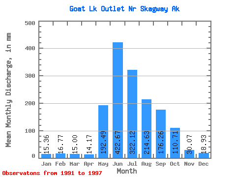
| Statistic | Jan | Feb | Mar | Apr | May | Jun | Jul | Aug | Sep | Oct | Nov | Dec | Annual |
|---|---|---|---|---|---|---|---|---|---|---|---|---|---|
| Mean | 15.20 | 16.89 | 15.00 | 14.10 | 192.54 | 422.50 | 321.95 | 214.74 | 176.09 | 110.53 | 30.03 | 18.99 | 1561.89 |
| Standard Deviation | 11.47 | 11.28 | 15.65 | 9.13 | 114.91 | 105.86 | 81.16 | 66.59 | 53.07 | 42.42 | 9.54 | 12.69 | 300.63 |
| Min | 2.11 | 7.18 | 5.46 | 6.73 | 53.85 | 316.77 | 235.66 | 134.41 | 110.83 | 76.78 | 19.09 | 0.63 | 1241.42 |
| Max | 34.92 | 33.12 | 46.67 | 30.71 | 371.81 | 602.52 | 450.26 | 273.34 | 240.73 | 180.62 | 40.75 | 35.44 | 1961.49 |
| Coefficient of Variation | 0.76 | 0.67 | 1.04 | 0.65 | 0.60 | 0.25 | 0.25 | 0.31 | 0.30 | 0.38 | 0.32 | 0.67 | 0.19 |
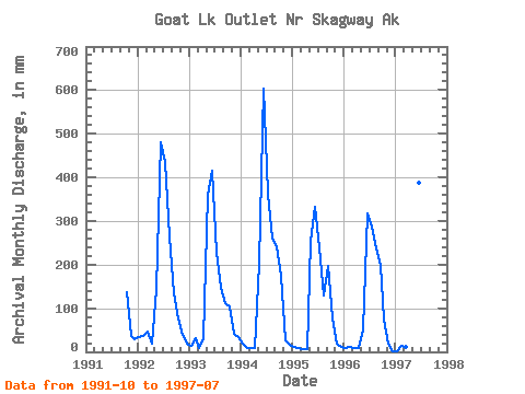
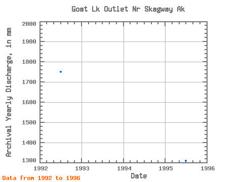
| Year | Jan | Feb | Mar | Apr | May | Jun | Jul | Aug | Sep | Oct | Nov | Dec | Annual | 1991 | 140.82 | 35.66 | 30.14 | 1992 | 34.92 | 33.12 | 46.67 | 18.73 | 150.44 | 479.20 | 450.26 | 273.34 | 132.90 | 78.45 | 38.14 | 19.97 | 1749.81 | 1993 | 14.26 | 29.32 | 8.90 | 30.71 | 371.81 | 415.95 | 235.66 | 151.56 | 110.83 | 107.49 | 40.75 | 35.44 | 1547.01 | 1994 | 20.74 | 9.10 | 8.37 | 9.95 | 209.01 | 602.52 | 373.49 | 268.44 | 240.73 | 180.62 | 27.23 | 16.99 | 1961.49 | 1995 | 10.71 | 7.18 | 5.46 | 6.73 | 264.09 | 333.38 | 246.73 | 134.41 | 197.01 | 79.04 | 19.09 | 10.77 | 1309.71 | 1996 | 8.45 | 10.42 | 8.64 | 8.74 | 53.85 | 316.77 | 296.37 | 245.97 | 198.96 | 76.78 | 19.30 | 0.63 | 1241.42 | 1997 | 2.11 | 12.19 | 11.97 | 9.73 | 106.04 | 387.20 | 329.21 |
|---|
 Return to R-Arctic Net Home Page