|
|
|||||||||||||||||
| Point ID: 9313 | Downloads | Plots | Site Data | Code: 15056070 |
|
|
|||||||||||||||||
| Download | |
|---|---|
| Site Descriptor Information | Site Time Series Data |
| Link to all available data | |

|
|
| View: | Statistics | Time Series |
| Units: | m3/s |
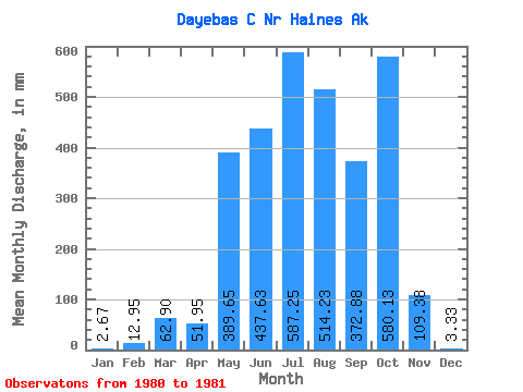
| Statistic | Jan | Feb | Mar | Apr | May | Jun | Jul | Aug | Sep | Oct | Nov | Dec | Annual |
|---|---|---|---|---|---|---|---|---|---|---|---|---|---|
| Mean | 2.70 | 13.02 | 62.94 | 51.94 | 389.56 | 437.65 | 587.10 | 514.11 | 372.87 | 580.08 | 109.41 | 3.31 | |
| Standard Deviation | 5.60 | 26.32 | 28.00 | 106.82 | |||||||||
| Min | 2.70 | 13.02 | 62.94 | 51.94 | 389.56 | 433.69 | 568.49 | 494.31 | 297.33 | 580.08 | 109.41 | 3.31 | |
| Max | 2.70 | 13.02 | 62.94 | 51.94 | 389.56 | 441.61 | 605.72 | 533.90 | 448.40 | 580.08 | 109.41 | 3.31 | |
| Coefficient of Variation | 0.01 | 0.04 | 0.05 | 0.29 |
| Year | Jan | Feb | Mar | Apr | May | Jun | Jul | Aug | Sep | Oct | Nov | Dec | Annual | 1980 | 441.61 | 605.72 | 494.31 | 297.33 | 580.08 | 109.41 | 3.31 | 1981 | 2.70 | 13.02 | 62.94 | 51.94 | 389.56 | 433.69 | 568.49 | 533.90 | 448.40 |
|---|
 Return to R-Arctic Net Home Page