|
|
|||||||||||||||||
| Point ID: 9292 | Downloads | Plots | Site Data | Code: 15081510 |
|
|
|||||||||||||||||
| Download | |
|---|---|
| Site Descriptor Information | Site Time Series Data |
| Link to all available data | |
|
|
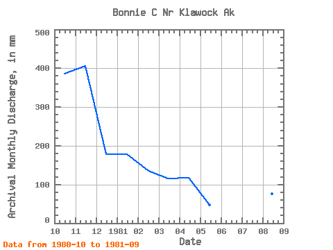
| View: | Statistics | Time Series |
| Units: | m3/s |
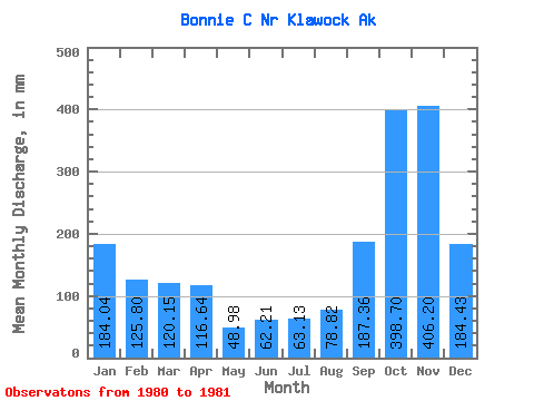
| Statistic | Jan | Feb | Mar | Apr | May | Jun | Jul | Aug | Sep | Oct | Nov | Dec | Annual |
|---|---|---|---|---|---|---|---|---|---|---|---|---|---|
| Mean | 184.14 | 126.74 | 120.13 | 116.79 | 49.09 | 62.02 | 63.12 | 78.78 | 187.54 | 398.68 | 406.14 | 184.46 | |
| Standard Deviation | |||||||||||||
| Min | 184.14 | 126.74 | 120.13 | 116.79 | 49.09 | 62.02 | 63.12 | 78.78 | 187.54 | 398.68 | 406.14 | 184.46 | |
| Max | 184.14 | 126.74 | 120.13 | 116.79 | 49.09 | 62.02 | 63.12 | 78.78 | 187.54 | 398.68 | 406.14 | 184.46 | |
| Coefficient of Variation |
| Year | Jan | Feb | Mar | Apr | May | Jun | Jul | Aug | Sep | Oct | Nov | Dec | Annual | 1980 | 398.68 | 406.14 | 184.46 | 1981 | 184.14 | 126.74 | 120.13 | 116.79 | 49.09 | 62.02 | 63.12 | 78.78 | 187.54 |
|---|
 Return to R-Arctic Net Home Page