|
|
|||||||||||||||||
| Point ID: 9268 | Downloads | Plots | Site Data | Code: 15014000 |
|
|
|||||||||||||||||
| Download | |
|---|---|
| Site Descriptor Information | Site Time Series Data |
| Link to all available data | |
|
|
| View: | Statistics | Time Series |
| Units: | m3/s |
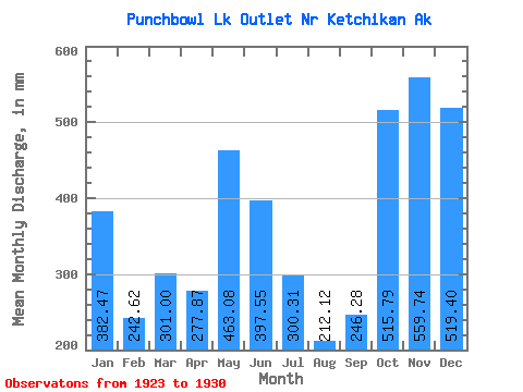
| Statistic | Jan | Feb | Mar | Apr | May | Jun | Jul | Aug | Sep | Oct | Nov | Dec | Annual |
|---|---|---|---|---|---|---|---|---|---|---|---|---|---|
| Mean | 382.45 | 244.67 | 300.98 | 277.88 | 462.98 | 397.56 | 300.25 | 212.10 | 246.29 | 515.73 | 559.73 | 519.29 | 4418.99 |
| Standard Deviation | 259.58 | 148.22 | 112.62 | 64.39 | 110.10 | 85.52 | 98.51 | 116.42 | 145.67 | 211.00 | 211.44 | 192.70 | 443.21 |
| Min | 85.33 | 48.24 | 148.81 | 184.95 | 321.31 | 279.04 | 157.15 | 95.56 | 89.53 | 92.03 | 266.53 | 236.44 | 3803.59 |
| Max | 856.64 | 444.30 | 477.57 | 372.34 | 577.25 | 507.63 | 436.75 | 416.18 | 504.81 | 724.04 | 903.51 | 836.74 | 4931.00 |
| Coefficient of Variation | 0.68 | 0.61 | 0.37 | 0.23 | 0.24 | 0.21 | 0.33 | 0.55 | 0.59 | 0.41 | 0.38 | 0.37 | 0.10 |
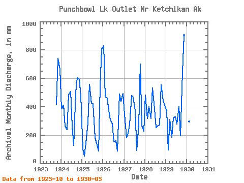
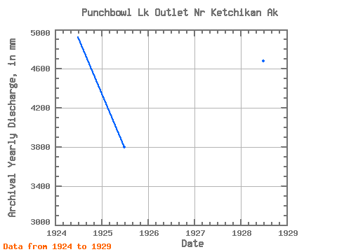
| Year | Jan | Feb | Mar | Apr | May | Jun | Jul | Aug | Sep | Oct | Nov | Dec | Annual | 1923 | 430.40 | 739.95 | 685.18 | 1924 | 397.22 | 385.73 | 273.72 | 236.79 | 502.37 | 507.63 | 274.00 | 132.93 | 504.81 | 623.67 | 593.00 | 490.42 | 4931.00 | 1925 | 104.53 | 48.24 | 148.81 | 284.69 | 577.25 | 420.71 | 436.75 | 188.80 | 142.38 | 92.03 | 541.24 | 836.74 | 3803.59 | 1926 | 856.64 | 444.30 | 477.57 | 372.34 | 321.31 | 279.04 | 157.15 | 166.60 | 89.53 | 504.49 | 435.18 | 510.64 | 4612.96 | 1927 | 358.05 | 169.81 | 221.50 | 273.07 | 494.27 | 466.20 | 384.13 | 95.56 | 273.62 | 724.04 | 266.53 | 236.44 | 3950.15 | 1928 | 496.79 | 297.01 | 411.61 | 315.46 | 550.91 | 384.93 | 260.82 | 272.54 | 271.32 | 571.12 | 438.73 | 425.21 | 4686.69 | 1929 | 378.58 | 89.66 | 318.95 | 184.95 | 331.77 | 326.87 | 288.64 | 416.18 | 196.12 | 664.33 | 903.51 | 450.39 | 4529.52 | 1930 | 85.33 | 277.94 | 254.67 |
|---|
 Return to R-Arctic Net Home Page