|
|
|||||||||||||||||
| Point ID: 9221 | Downloads | Plots | Site Data | Code: 15209700 |
|
|
|||||||||||||||||
| Download | |
|---|---|
| Site Descriptor Information | Site Time Series Data |
| Link to all available data | |
|
|
| View: | Statistics | Time Series |
| Units: | m3/s |
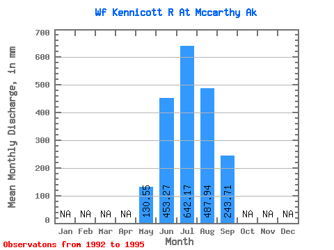
| Statistic | Jan | Feb | Mar | Apr | May | Jun | Jul | Aug | Sep | Oct | Nov | Dec | Annual |
|---|---|---|---|---|---|---|---|---|---|---|---|---|---|
| Mean | 130.53 | 453.27 | 642.07 | 487.87 | 243.71 | ||||||||
| Standard Deviation | 84.48 | 83.01 | 44.13 | 104.53 | 102.71 | ||||||||
| Min | 70.80 | 388.47 | 590.05 | 351.25 | 128.46 | ||||||||
| Max | 190.27 | 574.52 | 696.35 | 593.99 | 337.16 | ||||||||
| Coefficient of Variation | 0.65 | 0.18 | 0.07 | 0.21 | 0.42 |
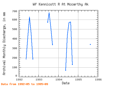
| Year | Jan | Feb | Mar | Apr | May | Jun | Jul | Aug | Sep | Oct | Nov | Dec | Annual | 1992 | 190.27 | 415.60 | 650.63 | 468.56 | 186.08 | 1993 | 574.52 | 696.35 | 537.67 | 337.16 | 1994 | 70.80 | 434.49 | 590.05 | 593.99 | 128.46 | 1995 | 388.47 | 631.26 | 351.25 | 323.15 |
|---|
 Return to R-Arctic Net Home Page