|
|
|||||||||||||||||
| Point ID: 9210 | Downloads | Plots | Site Data | Code: 15238978 |
|
|
|||||||||||||||||
| Download | |
|---|---|
| Site Descriptor Information | Site Time Series Data |
| Link to all available data | |
|
|
| View: | Statistics | Time Series |
| Units: | m3/s |
| Statistic | Jan | Feb | Mar | Apr | May | Jun | Jul | Aug | Sep | Oct | Nov | Dec | Annual |
|---|---|---|---|---|---|---|---|---|---|---|---|---|---|
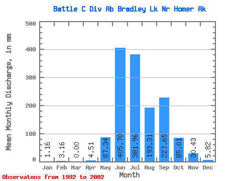
| Mean | 1.32 | 3.44 | 0.07 | 4.02 | 87.37 | 405.35 | 381.91 | 193.65 | 227.78 | 84.83 | 30.55 | 5.59 | 1492.59 |
| Standard Deviation | 2.13 | 5.87 | 0.15 | 7.49 | 73.71 | 200.35 | 182.20 | 137.75 | 144.57 | 55.60 | 28.99 | 12.49 | 545.32 |
| Min | 0.00 | 0.00 | 0.00 | 0.00 | 7.02 | 0.00 | 60.55 | 3.04 | 28.89 | 7.02 | 0.30 | 0.00 | 410.84 |
| Max | 6.35 | 14.44 | 0.49 | 21.30 | 252.89 | 749.84 | 661.35 | 478.28 | 539.10 | 192.64 | 90.19 | 40.34 | 2097.45 |
| Coefficient of Variation | 1.62 | 1.71 | 2.29 | 1.86 | 0.84 | 0.49 | 0.48 | 0.71 | 0.64 | 0.66 | 0.95 | 2.23 | 0.36 |
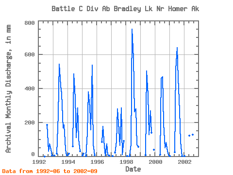
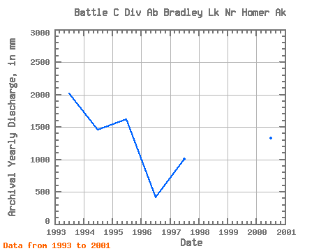
| Year | Jan | Feb | Mar | Apr | May | Jun | Jul | Aug | Sep | Oct | Nov | Dec | Annual | 1992 | 0.00 | 189.74 | 28.89 | 77.07 | 42.86 | 3.83 | 1993 | 0.00 | 4.05 | 0.15 | 14.24 | 252.89 | 543.23 | 429.64 | 382.09 | 168.52 | 192.64 | 41.77 | 4.21 | 2022.03 | 1994 | 3.42 | 14.44 | 0.00 | 0.00 | 61.52 | 484.78 | 353.96 | 115.72 | 283.81 | 104.79 | 29.19 | 0.04 | 1452.80 | 1995 | 6.35 | 14.21 | 0.00 | 2.52 | 141.26 | 380.76 | 298.07 | 160.83 | 539.10 | 72.60 | 6.39 | 0.00 | 1625.01 | 1996 | 0.00 | 0.00 | 0.00 | 0.11 | 85.75 | 176.93 | 60.55 | 3.04 | 73.25 | 7.02 | 3.27 | 0.00 | 410.84 | 1997 | 0.00 | 0.61 | 0.04 | 21.30 | 91.23 | 280.39 | 159.52 | 66.07 | 285.61 | 9.50 | 90.19 | 0.00 | 1008.40 | 1998 | 0.00 | 1.10 | 0.49 | 1.80 | 72.45 | 749.84 | 598.48 | 269.60 | 280.80 | 68.51 | 56.50 | 0.00 | 2097.45 | 1999 | 0.00 | 0.00 | 0.00 | 0.00 | 7.02 | 502.21 | 376.08 | 130.56 | 266.94 | 144.75 | 0.30 | 40.34 | 1466.48 | 2000 | 0.00 | 0.00 | 0.00 | 0.00 | 11.68 | 460.29 | 485.53 | 200.94 | 50.04 | 84.58 | 32.83 | 7.47 | 1327.50 | 2001 | 2.25 | 0.00 | 0.00 | 0.00 | 24.00 | 510.55 | 661.35 | 478.28 | 268.63 | 86.76 | 2.18 | 0.00 | 2022.83 | 2002 | 1.16 | 0.00 | 0.00 | 0.23 | 125.90 | 369.87 | 395.88 | 133.22 | 259.99 |
|---|
 Return to R-Arctic Net Home Page