|
|
|||||||||||||||||
| Point ID: 9189 | Downloads | Plots | Site Data | Code: 15237800 |
|
|
|||||||||||||||||
| Download | |
|---|---|
| Site Descriptor Information | Site Time Series Data |
| Link to all available data | |
|
|
| View: | Statistics | Time Series |
| Units: | m3/s |
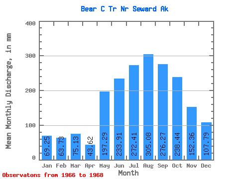
| Statistic | Jan | Feb | Mar | Apr | May | Jun | Jul | Aug | Sep | Oct | Nov | Dec | Annual |
|---|---|---|---|---|---|---|---|---|---|---|---|---|---|
| Mean | 69.48 | 64.46 | 75.06 | 43.69 | 197.28 | 233.68 | 272.05 | 304.77 | 276.54 | 238.26 | 152.14 | 107.81 | 2235.71 |
| Standard Deviation | 20.55 | 23.62 | 34.55 | 3.25 | 18.80 | 20.95 | 19.86 | 48.97 | 248.04 | 2.21 | 56.40 | 33.00 | |
| Min | 54.95 | 47.76 | 50.63 | 41.39 | 183.98 | 218.87 | 258.00 | 270.14 | 101.15 | 236.70 | 112.26 | 84.47 | 2235.71 |
| Max | 84.01 | 81.16 | 99.49 | 45.98 | 210.57 | 248.50 | 286.09 | 339.40 | 451.94 | 239.82 | 192.02 | 131.14 | 2235.71 |
| Coefficient of Variation | 0.30 | 0.37 | 0.46 | 0.07 | 0.10 | 0.09 | 0.07 | 0.16 | 0.90 | 0.01 | 0.37 | 0.31 |
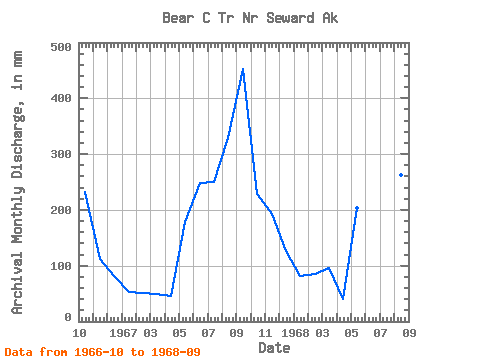
| Year | Jan | Feb | Mar | Apr | May | Jun | Jul | Aug | Sep | Oct | Nov | Dec | Annual | 1966 | 239.82 | 112.26 | 84.47 | 1967 | 54.95 | 47.76 | 50.63 | 45.98 | 183.98 | 248.50 | 258.00 | 339.40 | 451.94 | 236.70 | 192.02 | 131.14 | 2235.71 | 1968 | 84.01 | 81.16 | 99.49 | 41.39 | 210.57 | 218.87 | 286.09 | 270.14 | 101.15 |
|---|
 Return to R-Arctic Net Home Page