|
|
|||||||||||||||||
| Point ID: 9183 | Downloads | Plots | Site Data | Code: 15093200 |
|
|
|||||||||||||||||
| Download | |
|---|---|
| Site Descriptor Information | Site Time Series Data |
| Link to all available data | |
|
|
| View: | Statistics | Time Series |
| Units: | m3/s |
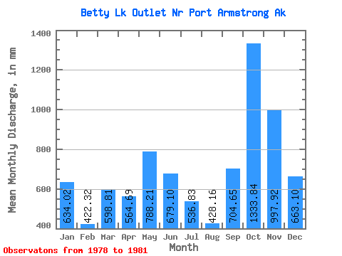
| Statistic | Jan | Feb | Mar | Apr | May | Jun | Jul | Aug | Sep | Oct | Nov | Dec | Annual |
|---|---|---|---|---|---|---|---|---|---|---|---|---|---|
| Mean | 633.99 | 426.05 | 598.56 | 564.82 | 787.93 | 679.10 | 536.62 | 427.92 | 704.71 | 1333.66 | 997.88 | 663.16 | 8370.34 |
| Standard Deviation | 467.04 | 255.72 | 44.16 | 306.00 | 319.69 | 280.54 | 246.55 | 131.53 | 181.73 | 372.39 | 397.07 | 248.78 | 1261.26 |
| Min | 278.72 | 134.22 | 566.50 | 361.76 | 486.48 | 418.73 | 310.65 | 312.78 | 535.10 | 968.68 | 700.42 | 475.26 | 7478.49 |
| Max | 1163.01 | 610.93 | 648.93 | 916.76 | 1123.18 | 976.20 | 799.57 | 601.77 | 959.07 | 1713.04 | 1448.77 | 945.30 | 9262.19 |
| Coefficient of Variation | 0.74 | 0.60 | 0.07 | 0.54 | 0.41 | 0.41 | 0.46 | 0.31 | 0.26 | 0.28 | 0.40 | 0.38 | 0.15 |
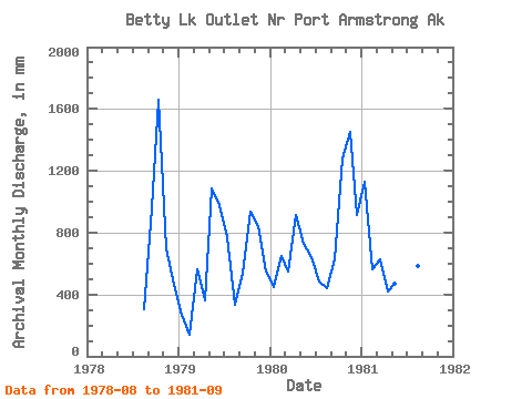
| Year | Jan | Feb | Mar | Apr | May | Jun | Jul | Aug | Sep | Oct | Nov | Dec | Annual | 1978 | 312.78 | 959.07 | 1713.04 | 700.42 | 475.26 | 1979 | 278.72 | 134.22 | 580.25 | 361.76 | 1123.18 | 976.20 | 799.57 | 340.71 | 535.10 | 968.68 | 844.45 | 568.92 | 7478.49 | 1980 | 460.25 | 610.93 | 566.50 | 916.76 | 754.12 | 642.37 | 499.64 | 456.40 | 630.55 | 1319.26 | 1448.77 | 945.30 | 9262.19 | 1981 | 1163.01 | 533.00 | 648.93 | 415.93 | 486.48 | 418.73 | 310.65 | 601.77 | 694.13 |
|---|
 Return to R-Arctic Net Home Page