|
|
|||||||||||||||||
| Point ID: 9182 | Downloads | Plots | Site Data | Code: 15092000 |
|
|
|||||||||||||||||
| Download | |
|---|---|
| Site Descriptor Information | Site Time Series Data |
| Link to all available data | |
|
|
| View: | Statistics | Time Series |
| Units: | m3/s |
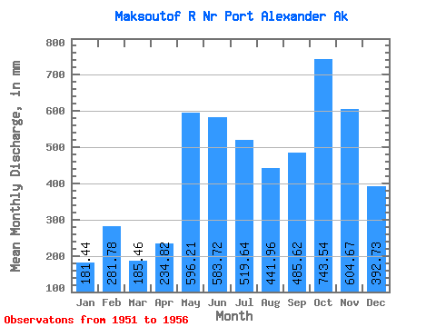
| Statistic | Jan | Feb | Mar | Apr | May | Jun | Jul | Aug | Sep | Oct | Nov | Dec | Annual |
|---|---|---|---|---|---|---|---|---|---|---|---|---|---|
| Mean | 181.43 | 284.21 | 185.44 | 234.84 | 596.12 | 583.71 | 519.55 | 441.89 | 485.62 | 743.45 | 604.67 | 392.65 | 5469.44 |
| Standard Deviation | 78.83 | 143.86 | 82.72 | 87.58 | 158.96 | 60.99 | 96.05 | 168.90 | 168.97 | 235.05 | 249.41 | 210.30 | 476.61 |
| Min | 89.90 | 134.82 | 105.05 | 118.16 | 438.90 | 506.07 | 433.14 | 207.44 | 300.86 | 472.70 | 233.35 | 135.66 | 4922.86 |
| Max | 307.57 | 510.90 | 277.41 | 349.06 | 807.47 | 650.14 | 695.60 | 663.75 | 755.82 | 1096.80 | 916.54 | 668.84 | 5916.99 |
| Coefficient of Variation | 0.43 | 0.51 | 0.45 | 0.37 | 0.27 | 0.10 | 0.18 | 0.38 | 0.35 | 0.32 | 0.41 | 0.54 | 0.09 |
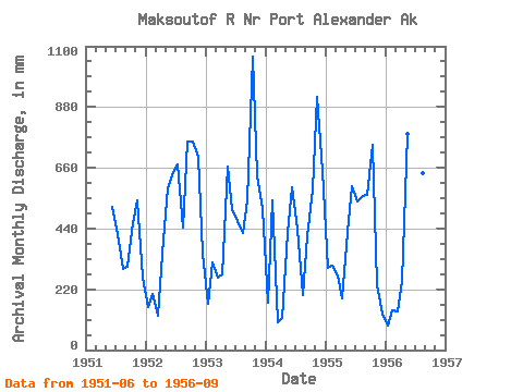
| Year | Jan | Feb | Mar | Apr | May | Jun | Jul | Aug | Sep | Oct | Nov | Dec | Annual | 1951 | 516.94 | 433.14 | 302.31 | 300.86 | 472.70 | 541.16 | 270.40 | 1952 | 159.57 | 189.93 | 126.49 | 349.06 | 604.79 | 643.02 | 695.60 | 459.98 | 755.82 | 781.04 | 698.45 | 359.59 | 5816.87 | 1953 | 173.74 | 297.36 | 271.80 | 272.64 | 686.47 | 506.07 | 481.56 | 439.46 | 542.54 | 1096.80 | 633.85 | 528.79 | 5916.99 | 1954 | 176.36 | 510.90 | 105.05 | 118.16 | 438.90 | 591.36 | 456.10 | 207.44 | 410.17 | 599.12 | 916.54 | 668.84 | 5221.04 | 1955 | 307.57 | 288.05 | 277.41 | 185.81 | 442.97 | 594.74 | 558.04 | 578.40 | 562.71 | 767.60 | 233.35 | 135.66 | 4922.86 | 1956 | 89.90 | 134.82 | 146.47 | 248.52 | 807.47 | 650.14 | 492.86 | 663.75 | 341.65 |
|---|
 Return to R-Arctic Net Home Page