|
|
|||||||||||||||||
| Point ID: 9179 | Downloads | Plots | Site Data | Code: 15088000 |
|
|
|||||||||||||||||
| Download | |
|---|---|
| Site Descriptor Information | Site Time Series Data |
| Link to all available data | |
|
|
| View: | Statistics | Time Series |
| Units: | m3/s |
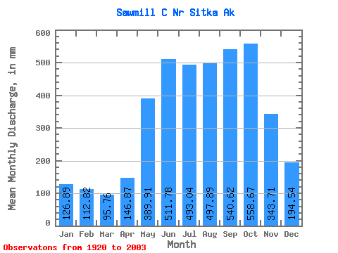
| Statistic | Jan | Feb | Mar | Apr | May | Jun | Jul | Aug | Sep | Oct | Nov | Dec | Annual |
|---|---|---|---|---|---|---|---|---|---|---|---|---|---|
| Mean | 126.88 | 113.78 | 95.76 | 146.87 | 389.84 | 511.79 | 492.97 | 497.83 | 540.62 | 558.59 | 343.70 | 194.52 | 4122.38 |
| Standard Deviation | 79.87 | 91.08 | 64.66 | 88.98 | 144.83 | 182.17 | 151.16 | 169.35 | 169.98 | 176.95 | 162.25 | 150.04 | 724.83 |
| Min | 22.43 | 22.67 | 18.60 | 44.67 | 45.27 | 39.15 | 65.31 | 87.00 | 260.86 | 265.67 | 57.05 | 37.64 | 2599.89 |
| Max | 375.14 | 440.24 | 274.18 | 481.64 | 646.21 | 856.67 | 732.66 | 927.60 | 935.08 | 904.30 | 725.06 | 614.31 | 6113.73 |
| Coefficient of Variation | 0.63 | 0.80 | 0.68 | 0.61 | 0.37 | 0.36 | 0.31 | 0.34 | 0.31 | 0.32 | 0.47 | 0.77 | 0.18 |
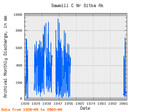
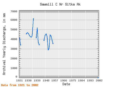
| Year | Jan | Feb | Mar | Apr | May | Jun | Jul | Aug | Sep | Oct | Nov | Dec | Annual | 1920 | 269.15 | 280.59 | 243.03 | 67.82 | 1921 | 63.73 | 77.26 | 48.41 | 92.10 | 312.46 | 705.51 | 544.51 | 499.54 | 575.99 | 721.03 | 185.82 | 325.27 | 4135.42 | 1922 | 102.40 | 34.30 | 18.60 | 83.50 | 366.52 | 512.45 | 480.61 | 520.29 | 574.70 | 265.67 | 350.90 | 102.84 | 3404.48 | 1923 | 32.07 | 1928 | 122.80 | 169.54 | 135.20 | 167.62 | 461.90 | 637.51 | 572.83 | 544.39 | 559.90 | 570.14 | 322.70 | 314.33 | 4568.02 | 1929 | 268.72 | 98.34 | 193.13 | 139.62 | 450.30 | 606.56 | 565.30 | 529.47 | 391.43 | 697.68 | 575.70 | 186.76 | 4683.94 | 1930 | 62.12 | 136.81 | 104.49 | 213.24 | 424.23 | 561.31 | 539.92 | 492.46 | 578.72 | 495.97 | 403.30 | 614.31 | 4614.29 | 1931 | 178.52 | 234.47 | 79.25 | 214.38 | 470.04 | 587.71 | 552.49 | 545.07 | 530.83 | 660.96 | 256.94 | 111.85 | 4417.52 | 1932 | 170.46 | 100.66 | 99.95 | 217.53 | 417.60 | 625.16 | 543.05 | 512.86 | 684.34 | 545.82 | 264.99 | 107.92 | 4281.47 | 1933 | 96.17 | 92.25 | 43.08 | 122.11 | 502.64 | 525.21 | 595.55 | 691.24 | 327.43 | 531.89 | 600.26 | 93.10 | 4205.44 | 1934 | 187.39 | 253.51 | 135.37 | 263.82 | 439.55 | 501.62 | 521.34 | 626.57 | 394.21 | 610.42 | 245.53 | 164.67 | 4336.20 | 1935 | 105.02 | 440.24 | 116.38 | 158.86 | 570.64 | 752.38 | 732.66 | 766.68 | 755.24 | 450.49 | 725.06 | 529.37 | 6113.73 | 1936 | 208.66 | 66.86 | 265.57 | 481.64 | 646.21 | 856.67 | 674.49 | 602.66 | 829.36 | 1937 | 904.30 | 196.57 | 279.30 | 1938 | 162.23 | 183.29 | 160.22 | 132.70 | 437.92 | 484.81 | 431.63 | 430.05 | 597.45 | 513.56 | 337.17 | 302.75 | 4167.07 | 1939 | 194.36 | 121.57 | 102.89 | 148.44 | 328.52 | 567.07 | 645.48 | 927.60 | 737.03 | 809.74 | 362.12 | 257.07 | 5179.43 | 1940 | 130.06 | 109.24 | 97.68 | 202.09 | 359.11 | 388.67 | 361.69 | 553.06 | 549.44 | 477.98 | 277.31 | 196.42 | 3693.04 | 1941 | 143.02 | 155.59 | 161.62 | 234.12 | 263.13 | 424.71 | 403.85 | 220.79 | 260.86 | 678.37 | 389.13 | 90.75 | 3422.07 | 1942 | 375.14 | 157.71 | 96.47 | 188.17 | 528.31 | 399.55 | 515.29 | 503.37 | 508.84 | 1945 | 819.02 | 221.62 | 96.12 | 1946 | 84.38 | 37.04 | 54.98 | 70.71 | 483.86 | 600.04 | 458.47 | 419.42 | 483.48 | 571.61 | 564.07 | 69.56 | 3887.30 | 1947 | 123.04 | 67.48 | 274.18 | 217.04 | 500.33 | 426.75 | 349.55 | 414.50 | 935.08 | 453.57 | 463.69 | 165.78 | 4385.29 | 1948 | 271.84 | 50.31 | 39.53 | 44.67 | 504.11 | 565.81 | 582.82 | 454.36 | 885.32 | 478.23 | 616.34 | 83.68 | 4568.65 | 1949 | 181.79 | 55.48 | 98.04 | 120.42 | 422.44 | 658.47 | 535.63 | 466.28 | 504.09 | 721.78 | 425.32 | 93.37 | 4267.32 | 1950 | 37.55 | 30.78 | 33.66 | 54.77 | 265.63 | 594.23 | 600.64 | 415.11 | 417.35 | 287.11 | 120.08 | 37.64 | 2884.25 | 1951 | 55.68 | 22.67 | 35.07 | 117.71 | 385.22 | 566.13 | 446.06 | 337.04 | 400.27 | 318.93 | 225.79 | 124.32 | 3025.35 | 1952 | 49.99 | 46.66 | 43.91 | 128.97 | 395.95 | 516.49 | 648.05 | 427.65 | 796.57 | 780.61 | 474.71 | 151.76 | 4448.28 | 1953 | 79.25 | 92.11 | 98.31 | 156.44 | 512.95 | 575.11 | 483.42 | 606.10 | 530.86 | 795.60 | 221.26 | 227.18 | 4357.29 | 1954 | 86.73 | 273.54 | 42.48 | 46.90 | 343.27 | 542.20 | 466.48 | 366.91 | 540.45 | 364.27 | 390.87 | 459.09 | 3928.60 | 1955 | 118.63 | 99.36 | 106.11 | 83.16 | 240.09 | 553.58 | 668.47 | 535.99 | 529.28 | 397.57 | 180.22 | 39.50 | 3541.68 | 1956 | 22.43 | 43.36 | 41.49 | 112.37 | 522.30 | 483.69 | 550.48 | 656.28 | 401.02 | 406.51 | 445.64 | 402.46 | 4065.91 | 1957 | 99.64 | 56.34 | 42.21 | 98.76 | 372.14 | 495.01 | 407.64 | 318.95 | 477.86 | 2001 | 63.97 | 60.63 | 124.09 | 218.34 | 505.57 | 455.89 | 57.05 | 59.95 | 2002 | 61.20 | 54.92 | 47.30 | 46.34 | 45.27 | 39.15 | 214.21 | 742.68 | 427.47 | 692.37 | 167.77 | 80.70 | 2599.89 | 2003 | 58.32 | 51.74 | 57.18 | 47.82 | 48.56 | 51.26 | 65.31 | 87.00 | 340.29 |
|---|
 Return to R-Arctic Net Home Page