|
|
|||||||||||||||||
| Point ID: 9171 | Downloads | Plots | Site Data | Code: 15087560 |
|
|
|||||||||||||||||
| Download | |
|---|---|
| Site Descriptor Information | Site Time Series Data |
| Link to all available data | |
|
|
| View: | Statistics | Time Series |
| Units: | m3/s |
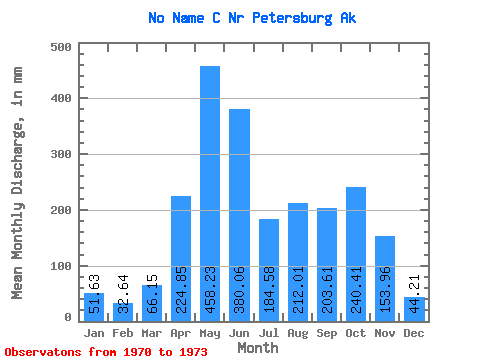
| Statistic | Jan | Feb | Mar | Apr | May | Jun | Jul | Aug | Sep | Oct | Nov | Dec | Annual |
|---|---|---|---|---|---|---|---|---|---|---|---|---|---|
| Mean | 51.73 | 32.89 | 66.16 | 224.79 | 458.12 | 380.15 | 184.56 | 211.82 | 203.50 | 240.38 | 153.97 | 44.05 | 2374.09 |
| Standard Deviation | 12.87 | 22.59 | 45.99 | 168.41 | 32.88 | 117.18 | 79.26 | 76.43 | 44.56 | 137.96 | 110.47 | 16.30 | 47.06 |
| Min | 37.47 | 14.66 | 15.94 | 53.88 | 420.65 | 246.72 | 128.41 | 153.56 | 159.10 | 91.98 | 31.39 | 26.60 | 2340.81 |
| Max | 62.46 | 58.16 | 106.20 | 390.58 | 482.17 | 466.30 | 275.22 | 298.36 | 248.23 | 364.74 | 245.82 | 58.89 | 2407.36 |
| Coefficient of Variation | 0.25 | 0.69 | 0.69 | 0.75 | 0.07 | 0.31 | 0.43 | 0.36 | 0.22 | 0.57 | 0.72 | 0.37 | 0.02 |
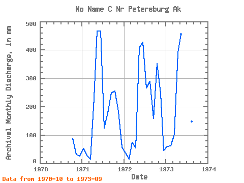
| Year | Jan | Feb | Mar | Apr | May | Jun | Jul | Aug | Sep | Oct | Nov | Dec | Annual | 1970 | 91.98 | 31.39 | 26.60 | 1971 | 55.27 | 25.85 | 15.94 | 229.92 | 482.17 | 466.30 | 128.41 | 183.55 | 248.23 | 264.42 | 184.70 | 58.89 | 2340.81 | 1972 | 37.47 | 14.66 | 76.35 | 53.88 | 420.65 | 427.42 | 275.22 | 298.36 | 159.10 | 364.74 | 245.82 | 46.65 | 2407.36 | 1973 | 62.46 | 58.16 | 106.20 | 390.58 | 471.55 | 246.72 | 150.03 | 153.56 | 203.15 |
|---|
 Return to R-Arctic Net Home Page