|
|
|||||||||||||||||
| Point ID: 9169 | Downloads | Plots | Site Data | Code: 15087200 |
|
|
|||||||||||||||||
| Download | |
|---|---|
| Site Descriptor Information | Site Time Series Data |
| Link to all available data | |
|
|
| View: | Statistics | Time Series |
| Units: | m3/s |
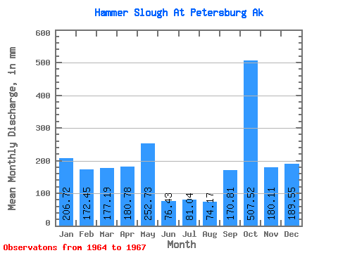
| Statistic | Jan | Feb | Mar | Apr | May | Jun | Jul | Aug | Sep | Oct | Nov | Dec | Annual |
|---|---|---|---|---|---|---|---|---|---|---|---|---|---|
| Mean | 206.62 | 174.09 | 177.20 | 181.02 | 252.49 | 76.61 | 80.80 | 74.41 | 171.08 | 507.73 | 180.04 | 189.71 | 2283.74 |
| Standard Deviation | 129.73 | 55.17 | 220.59 | 58.00 | 123.99 | 16.09 | 106.34 | 46.25 | 135.21 | 80.37 | 53.54 | 48.12 | 292.93 |
| Min | 105.39 | 131.16 | 24.39 | 122.09 | 149.01 | 60.59 | 11.67 | 28.09 | 17.08 | 425.20 | 141.81 | 134.17 | 2076.61 |
| Max | 352.86 | 236.31 | 430.10 | 238.04 | 389.92 | 92.78 | 203.25 | 120.59 | 270.30 | 585.75 | 241.23 | 218.63 | 2490.87 |
| Coefficient of Variation | 0.63 | 0.32 | 1.25 | 0.32 | 0.49 | 0.21 | 1.32 | 0.62 | 0.79 | 0.16 | 0.30 | 0.25 | 0.13 |
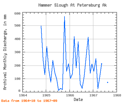
| Year | Jan | Feb | Mar | Apr | May | Jun | Jul | Aug | Sep | Oct | Nov | Dec | Annual | 1964 | 512.23 | 241.23 | 134.17 | 1965 | 352.86 | 154.80 | 77.13 | 238.04 | 149.01 | 92.78 | 11.67 | 28.09 | 17.08 | 585.75 | 157.07 | 218.63 | 2076.61 | 1966 | 105.39 | 131.16 | 430.10 | 182.92 | 389.92 | 60.59 | 27.47 | 120.59 | 270.30 | 425.20 | 141.81 | 216.34 | 2490.87 | 1967 | 161.61 | 236.31 | 24.39 | 122.09 | 218.54 | 76.47 | 203.25 | 74.56 | 225.86 |
|---|
 Return to R-Arctic Net Home Page