|
|
|||||||||||||||||
| Point ID: 9163 | Downloads | Plots | Site Data | Code: 15100500 |
|
|
|||||||||||||||||
| Download | |
|---|---|
| Site Descriptor Information | Site Time Series Data |
| Link to all available data | |
|
|
| View: | Statistics | Time Series |
| Units: | m3/s |
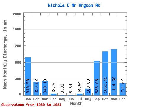
| Statistic | Jan | Feb | Mar | Apr | May | Jun | Jul | Aug | Sep | Oct | Nov | Dec | Annual |
|---|---|---|---|---|---|---|---|---|---|---|---|---|---|
| Mean | 915.99 | 331.14 | 350.44 | 47.23 | 9.50 | 7.78 | 44.63 | 172.20 | 836.06 | 1063.14 | 1115.14 | 292.56 | |
| Standard Deviation | |||||||||||||
| Min | 915.99 | 331.14 | 350.44 | 47.23 | 9.50 | 7.78 | 44.63 | 172.20 | 836.06 | 1063.14 | 1115.14 | 292.56 | |
| Max | 915.99 | 331.14 | 350.44 | 47.23 | 9.50 | 7.78 | 44.63 | 172.20 | 836.06 | 1063.14 | 1115.14 | 292.56 | |
| Coefficient of Variation |
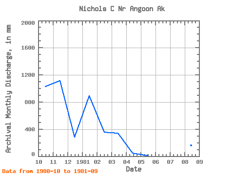
| Year | Jan | Feb | Mar | Apr | May | Jun | Jul | Aug | Sep | Oct | Nov | Dec | Annual | 1980 | 1063.14 | 1115.14 | 292.56 | 1981 | 915.99 | 331.14 | 350.44 | 47.23 | 9.50 | 7.78 | 44.63 | 172.20 | 836.06 |
|---|
 Return to R-Arctic Net Home Page