|
|
|||||||||||||||||
| Point ID: 9160 | Downloads | Plots | Site Data | Code: 15109048 |
|
|
|||||||||||||||||
| Download | |
|---|---|
| Site Descriptor Information | Site Time Series Data |
| Link to all available data | |
|
|
| View: | Statistics | Time Series |
| Units: | m3/s |
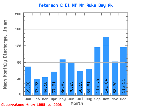
| Statistic | Jan | Feb | Mar | Apr | May | Jun | Jul | Aug | Sep | Oct | Nov | Dec | Annual |
|---|---|---|---|---|---|---|---|---|---|---|---|---|---|
| Mean | 70.03 | 39.64 | 44.12 | 57.81 | 86.87 | 78.31 | 58.19 | 64.97 | 116.87 | 141.51 | 82.20 | 116.37 | 1002.71 |
| Standard Deviation | 27.77 | 25.23 | 10.53 | 42.13 | 32.06 | 29.35 | 32.74 | 36.72 | 30.31 | 42.81 | 39.81 | 101.51 | 205.44 |
| Min | 38.02 | 12.47 | 28.29 | 19.95 | 39.58 | 26.54 | 17.61 | 27.00 | 87.43 | 108.92 | 32.97 | 56.70 | 761.98 |
| Max | 110.03 | 76.09 | 54.37 | 126.99 | 123.67 | 98.83 | 108.81 | 113.41 | 150.77 | 202.18 | 129.92 | 294.96 | 1249.70 |
| Coefficient of Variation | 0.40 | 0.64 | 0.24 | 0.73 | 0.37 | 0.38 | 0.56 | 0.56 | 0.26 | 0.30 | 0.48 | 0.87 | 0.20 |
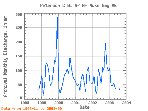
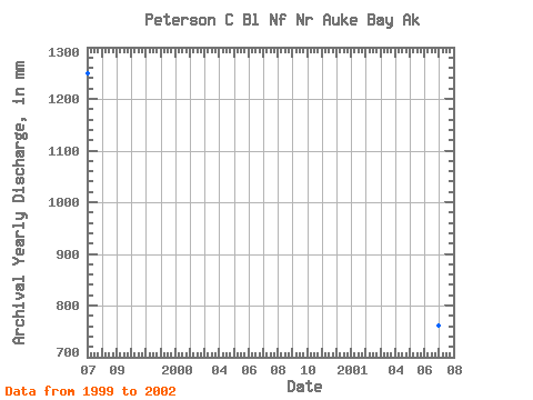
| Year | Jan | Feb | Mar | Apr | May | Jun | Jul | Aug | Sep | Oct | Nov | Dec | Annual | 1998 | 32.97 | 57.17 | 1999 | 84.39 | 12.47 | 50.89 | 126.99 | 123.67 | 98.83 | 49.94 | 56.28 | 87.43 | 140.95 | 129.92 | 294.96 | 1249.70 | 2000 | 38.02 | 19.27 | 38.97 | 58.76 | 87.19 | 92.21 | 108.81 | 91.72 | 148.53 | 108.92 | 76.95 | 71.12 | 937.79 | 2001 | 60.21 | 44.02 | 54.37 | 28.29 | 76.61 | 87.30 | 59.35 | 27.00 | 97.34 | 114.02 | 57.41 | 56.70 | 761.98 | 2002 | 57.51 | 76.09 | 28.29 | 19.95 | 107.30 | 86.67 | 55.25 | 113.41 | 100.27 | 202.18 | 113.77 | 101.89 | 1061.35 | 2003 | 110.03 | 46.36 | 48.07 | 55.07 | 39.58 | 26.54 | 17.61 | 36.42 | 150.77 |
|---|
 Return to R-Arctic Net Home Page