|
|
|||||||||||||||||
| Point ID: 9155 | Downloads | Plots | Site Data | Code: 15107000 |
|
|
|||||||||||||||||
| Download | |
|---|---|
| Site Descriptor Information | Site Time Series Data |
| Link to all available data | |
|
|
| View: | Statistics | Time Series |
| Units: | m3/s |
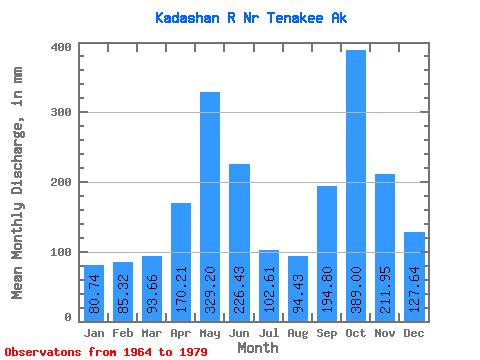
| Statistic | Jan | Feb | Mar | Apr | May | Jun | Jul | Aug | Sep | Oct | Nov | Dec | Annual |
|---|---|---|---|---|---|---|---|---|---|---|---|---|---|
| Mean | 80.72 | 86.05 | 93.66 | 170.22 | 329.15 | 226.42 | 102.59 | 94.42 | 194.79 | 388.94 | 211.95 | 127.62 | 2141.00 |
| Standard Deviation | 54.49 | 73.53 | 49.97 | 63.41 | 89.88 | 90.68 | 40.19 | 50.52 | 93.03 | 176.25 | 100.28 | 62.28 | 219.29 |
| Min | 15.29 | 15.35 | 28.95 | 76.00 | 173.94 | 88.11 | 37.51 | 29.80 | 51.71 | 146.90 | 43.42 | 26.77 | 1772.96 |
| Max | 199.00 | 256.88 | 207.75 | 281.23 | 521.70 | 366.13 | 166.61 | 179.53 | 392.76 | 745.39 | 387.77 | 213.04 | 2594.05 |
| Coefficient of Variation | 0.68 | 0.85 | 0.53 | 0.37 | 0.27 | 0.40 | 0.39 | 0.54 | 0.48 | 0.45 | 0.47 | 0.49 | 0.10 |
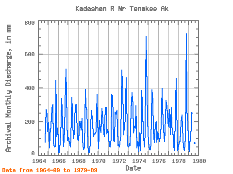
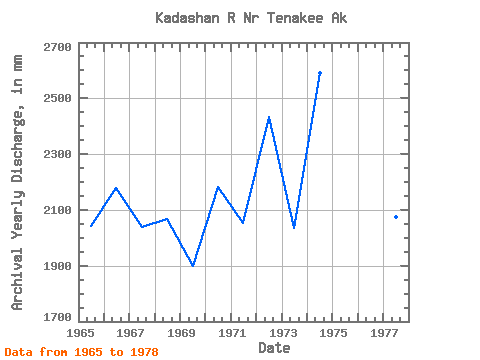
| Year | Jan | Feb | Mar | Apr | May | Jun | Jul | Aug | Sep | Oct | Nov | Dec | Annual | 1964 | 79.42 | 283.12 | 242.32 | 145.77 | 1965 | 199.00 | 42.10 | 129.30 | 174.57 | 289.86 | 303.34 | 79.44 | 53.06 | 51.71 | 456.53 | 109.62 | 168.53 | 2045.05 | 1966 | 15.29 | 15.35 | 76.57 | 195.70 | 347.13 | 197.68 | 55.89 | 149.13 | 308.05 | 528.92 | 209.21 | 90.43 | 2181.26 | 1967 | 109.75 | 70.46 | 50.75 | 101.95 | 354.03 | 196.70 | 102.73 | 133.86 | 290.53 | 311.47 | 223.68 | 98.98 | 2041.48 | 1968 | 91.31 | 191.53 | 207.75 | 150.63 | 227.05 | 88.11 | 37.51 | 45.19 | 392.76 | 297.13 | 264.69 | 64.71 | 2069.01 | 1969 | 21.53 | 18.31 | 67.27 | 266.57 | 263.77 | 173.66 | 114.45 | 130.58 | 127.47 | 146.90 | 359.67 | 212.29 | 1900.32 | 1970 | 43.81 | 196.07 | 163.69 | 135.57 | 284.70 | 210.76 | 166.61 | 113.29 | 285.19 | 294.12 | 128.39 | 158.10 | 2184.77 | 1971 | 114.29 | 53.58 | 50.75 | 98.29 | 372.75 | 355.48 | 89.89 | 83.84 | 255.64 | 253.57 | 266.71 | 59.98 | 2054.86 | 1972 | 67.72 | 46.28 | 100.36 | 118.19 | 521.70 | 366.13 | 127.09 | 179.53 | 206.16 | 475.36 | 177.22 | 58.65 | 2433.30 | 1973 | 51.96 | 65.46 | 59.27 | 269.55 | 383.42 | 301.03 | 137.91 | 178.93 | 163.01 | 302.74 | 43.42 | 84.06 | 2035.78 | 1974 | 23.05 | 124.19 | 28.95 | 161.48 | 397.74 | 233.78 | 98.04 | 50.42 | 153.51 | 726.22 | 387.77 | 213.04 | 2594.05 | 1975 | 77.70 | 32.92 | 33.79 | 76.00 | 401.55 | 321.27 | 151.13 | 77.60 | 179.96 | 205.42 | 78.71 | 144.29 | 1772.96 | 1976 | 107.92 | 76.11 | 117.12 | 167.50 | 411.04 | 274.33 | 156.67 | 85.07 | 223.25 | 335.18 | 289.43 | 203.59 | 2441.75 | 1977 | 179.43 | 256.88 | 129.83 | 281.23 | 173.94 | 144.06 | 63.52 | 29.80 | 178.00 | 472.07 | 128.32 | 26.77 | 2075.30 | 1978 | 61.71 | 79.01 | 83.91 | 199.79 | 248.28 | 97.33 | 51.86 | 30.95 | 100.00 | 745.39 | 270.10 | 185.09 | 2144.13 | 1979 | 46.37 | 22.55 | 105.54 | 156.22 | 260.26 | 132.56 | 106.13 | 74.96 | 122.05 |
|---|
 Return to R-Arctic Net Home Page