|
|
|||||||||||||||||
| Point ID: 9150 | Downloads | Plots | Site Data | Code: 15108000 |
|
|
|||||||||||||||||
| Download | |
|---|---|
| Site Descriptor Information | Site Time Series Data |
| Link to all available data | |
|
|
| View: | Statistics | Time Series |
| Units: | m3/s |
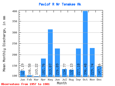
| Statistic | Jan | Feb | Mar | Apr | May | Jun | Jul | Aug | Sep | Oct | Nov | Dec | Annual |
|---|---|---|---|---|---|---|---|---|---|---|---|---|---|
| Mean | 127.16 | 107.51 | 103.20 | 182.76 | 313.82 | 226.88 | 134.76 | 132.13 | 227.19 | 396.43 | 229.73 | 147.15 | 2334.42 |
| Standard Deviation | 106.72 | 76.00 | 46.91 | 63.97 | 94.43 | 77.05 | 36.83 | 70.11 | 98.44 | 177.32 | 100.46 | 91.93 | 272.60 |
| Min | 18.49 | 15.75 | 25.32 | 68.77 | 135.61 | 87.20 | 66.25 | 44.38 | 66.75 | 138.10 | 39.95 | 29.28 | 1724.62 |
| Max | 472.67 | 301.41 | 224.75 | 307.36 | 568.81 | 413.35 | 197.12 | 304.51 | 435.18 | 937.49 | 495.07 | 317.46 | 2769.68 |
| Coefficient of Variation | 0.84 | 0.71 | 0.46 | 0.35 | 0.30 | 0.34 | 0.27 | 0.53 | 0.43 | 0.45 | 0.44 | 0.62 | 0.12 |
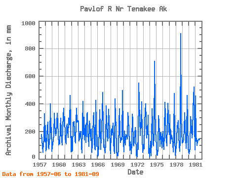
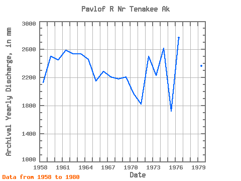
| Year | Jan | Feb | Mar | Apr | May | Jun | Jul | Aug | Sep | Oct | Nov | Dec | Annual | 1957 | 178.34 | 95.97 | 51.65 | 124.08 | 138.10 | 326.23 | 128.10 | 1958 | 250.18 | 57.04 | 77.36 | 186.24 | 277.29 | 87.20 | 74.17 | 140.17 | 150.88 | 413.87 | 192.65 | 233.69 | 2127.94 | 1959 | 55.61 | 107.92 | 143.97 | 173.59 | 342.51 | 250.37 | 197.12 | 177.34 | 191.91 | 267.61 | 333.10 | 263.60 | 2501.04 | 1960 | 104.11 | 102.95 | 114.34 | 219.10 | 303.93 | 195.07 | 137.73 | 105.20 | 240.73 | 381.20 | 237.50 | 317.46 | 2454.20 | 1961 | 152.61 | 120.48 | 114.34 | 233.88 | 260.57 | 211.87 | 159.28 | 304.51 | 247.93 | 477.03 | 257.80 | 52.78 | 2589.16 | 1962 | 168.09 | 52.65 | 65.30 | 259.99 | 275.26 | 270.29 | 137.94 | 120.52 | 269.28 | 379.65 | 267.53 | 281.30 | 2541.93 | 1963 | 288.84 | 254.56 | 133.78 | 143.41 | 205.65 | 200.24 | 94.39 | 44.73 | 249.25 | 431.14 | 176.67 | 313.03 | 2539.70 | 1964 | 142.88 | 230.26 | 122.62 | 202.18 | 332.36 | 334.12 | 165.75 | 164.98 | 91.91 | 282.81 | 241.12 | 139.97 | 2457.42 | 1965 | 224.59 | 46.45 | 107.61 | 185.38 | 301.05 | 335.06 | 129.39 | 74.71 | 66.75 | 439.38 | 90.00 | 161.55 | 2149.69 | 1966 | 21.78 | 25.18 | 114.45 | 205.96 | 369.69 | 220.70 | 71.31 | 162.76 | 319.57 | 497.21 | 200.71 | 87.39 | 2288.83 | 1967 | 105.00 | 61.51 | 47.48 | 115.68 | 397.03 | 242.13 | 134.33 | 168.32 | 361.27 | 278.30 | 217.51 | 83.61 | 2208.94 | 1968 | 37.96 | 188.93 | 224.75 | 172.28 | 268.38 | 121.74 | 66.25 | 44.38 | 435.18 | 306.34 | 237.11 | 66.12 | 2180.09 | 1969 | 24.70 | 21.26 | 77.62 | 267.64 | 376.46 | 185.54 | 122.28 | 145.61 | 150.57 | 145.18 | 495.07 | 201.50 | 2211.58 | 1970 | 53.28 | 189.76 | 126.32 | 103.85 | 184.38 | 160.75 | 177.16 | 149.57 | 335.72 | 296.50 | 123.18 | 65.26 | 1972.24 | 1971 | 126.43 | 81.09 | 40.06 | 118.98 | 333.76 | 284.34 | 109.46 | 99.95 | 176.28 | 235.48 | 186.16 | 30.49 | 1822.55 | 1972 | 20.38 | 15.75 | 121.92 | 68.77 | 568.81 | 413.35 | 174.60 | 271.06 | 226.88 | 427.56 | 161.27 | 48.50 | 2503.60 | 1973 | 73.00 | 99.77 | 74.28 | 270.18 | 413.48 | 282.70 | 158.76 | 243.61 | 178.07 | 325.94 | 39.95 | 80.03 | 2234.27 | 1974 | 18.49 | 118.71 | 25.32 | 141.35 | 375.56 | 249.25 | 117.85 | 97.96 | 171.88 | 730.40 | 369.63 | 209.43 | 2620.51 | 1975 | 96.80 | 29.77 | 26.37 | 76.28 | 325.16 | 268.81 | 181.97 | 93.30 | 185.58 | 198.88 | 78.88 | 171.16 | 1724.62 | 1976 | 205.34 | 103.03 | 72.81 | 188.77 | 424.10 | 315.72 | 175.58 | 99.29 | 254.65 | 417.06 | 301.95 | 216.66 | 2769.68 | 1977 | 183.60 | 301.41 | 117.33 | 206.11 | 149.42 | 166.48 | 112.83 | 55.15 | 178.31 | 492.47 | 157.18 | 29.28 | 2162.97 | 1978 | 66.42 | 78.38 | 151.05 | 229.57 | 288.49 | 161.61 | 107.08 | 55.73 | 135.44 | 937.49 | 309.69 | 204.92 | 2711.76 | 1979 | 121.23 | 116.39 | 148.99 | 209.61 | 347.53 | 225.95 | 157.23 | 80.74 | 156.87 | 476.95 | 254.69 | 77.86 | 2370.25 | 1980 | 37.84 | 54.17 | 74.59 | 307.36 | 275.30 | 210.46 | 156.85 | 204.18 | 367.76 | 537.66 | 257.84 | 67.94 | 2548.65 | 1981 | 472.67 | 122.72 | 154.16 | 100.04 | 135.61 | 99.96 | 153.74 | 147.90 | 412.92 |
|---|
 Return to R-Arctic Net Home Page