|
|
|||||||||||||||||
| Point ID: 9148 | Downloads | Plots | Site Data | Code: 15106960 |
|
|
|||||||||||||||||
| Download | |
|---|---|
| Site Descriptor Information | Site Time Series Data |
| Link to all available data | |
|
|
| View: | Statistics | Time Series |
| Units: | m3/s |
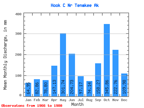
| Statistic | Jan | Feb | Mar | Apr | May | Jun | Jul | Aug | Sep | Oct | Nov | Dec | Annual |
|---|---|---|---|---|---|---|---|---|---|---|---|---|---|
| Mean | 64.95 | 83.53 | 78.78 | 147.15 | 301.65 | 204.78 | 97.19 | 74.17 | 158.26 | 345.81 | 222.75 | 110.01 | 1903.19 |
| Standard Deviation | 38.89 | 75.43 | 46.48 | 62.26 | 82.19 | 92.98 | 40.58 | 36.04 | 74.41 | 190.07 | 122.80 | 70.35 | 305.45 |
| Min | 17.77 | 11.84 | 27.46 | 39.74 | 151.26 | 84.38 | 31.83 | 26.59 | 78.34 | 108.96 | 41.41 | 33.02 | 1510.73 |
| Max | 146.42 | 268.94 | 180.22 | 266.76 | 451.07 | 371.36 | 172.71 | 144.88 | 343.70 | 780.17 | 426.21 | 229.14 | 2489.75 |
| Coefficient of Variation | 0.60 | 0.90 | 0.59 | 0.42 | 0.27 | 0.45 | 0.42 | 0.49 | 0.47 | 0.55 | 0.55 | 0.64 | 0.16 |
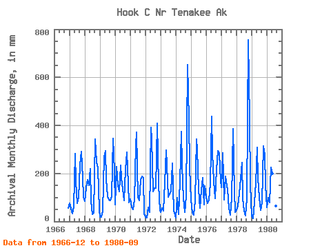
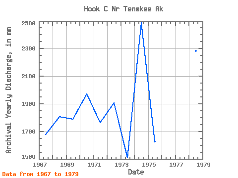
| Year | Jan | Feb | Mar | Apr | May | Jun | Jul | Aug | Sep | Oct | Nov | Dec | Annual | 1966 | 58.33 | 1967 | 77.94 | 49.09 | 34.36 | 61.64 | 290.71 | 166.29 | 79.95 | 101.25 | 234.38 | 299.32 | 182.96 | 104.69 | 1678.11 | 1968 | 87.33 | 131.10 | 180.22 | 149.98 | 226.77 | 84.38 | 31.83 | 38.33 | 343.70 | 255.25 | 221.73 | 49.14 | 1806.06 | 1969 | 19.77 | 18.07 | 47.28 | 266.76 | 303.23 | 176.81 | 109.32 | 92.41 | 87.94 | 108.96 | 344.29 | 217.21 | 1790.20 | 1970 | 72.89 | 213.98 | 153.04 | 123.87 | 240.94 | 182.73 | 138.56 | 90.27 | 215.59 | 297.33 | 157.31 | 80.69 | 1974.64 | 1971 | 97.25 | 54.35 | 51.19 | 89.91 | 328.76 | 371.36 | 101.04 | 90.86 | 172.93 | 192.62 | 182.26 | 33.02 | 1765.73 | 1972 | 19.57 | 15.94 | 59.65 | 39.74 | 405.71 | 342.41 | 128.85 | 144.88 | 139.47 | 422.71 | 154.23 | 46.34 | 1908.61 | 1973 | 41.25 | 52.11 | 47.27 | 161.45 | 306.18 | 233.54 | 104.27 | 116.28 | 125.51 | 249.12 | 41.41 | 36.22 | 1510.73 | 1974 | 17.77 | 93.16 | 30.38 | 165.82 | 386.08 | 231.77 | 99.36 | 38.99 | 103.66 | 673.60 | 425.61 | 229.14 | 2489.75 | 1975 | 92.31 | 34.45 | 27.46 | 88.17 | 354.65 | 298.54 | 139.07 | 57.36 | 129.30 | 188.73 | 71.62 | 152.19 | 1627.04 | 1976 | 103.99 | 72.36 | 92.72 | 157.08 | 451.07 | 285.54 | 172.71 | 97.91 | 217.94 | 302.51 | 283.44 | 176.43 | 2408.20 | 1977 | 146.42 | 268.94 | 93.47 | 188.40 | 151.26 | 132.38 | 57.96 | 26.95 | 96.02 | 399.67 | 127.53 | 39.17 | 1740.68 | 1978 | 49.98 | 59.90 | 120.97 | 180.25 | 254.54 | 95.25 | 46.19 | 26.59 | 95.19 | 780.17 | 426.21 | 158.81 | 2284.69 | 1979 | 21.93 | 11.84 | 82.73 | 160.38 | 318.59 | 177.75 | 102.07 | 49.95 | 78.34 | 325.56 | 277.09 | 158.70 | 1757.03 | 1980 | 60.88 | 94.11 | 82.18 | 226.58 | 204.56 | 88.14 | 49.42 | 66.39 | 175.74 |
|---|
 Return to R-Arctic Net Home Page